Missouri River rise

Wild and Free

Founding Member
Founding Member
Joined
Apr 24, 2015
Posts
4,815
Likes
53
Points
251
Location
west of mandan
Why is this not mandatory building code along any flood plane anymore? In a lot of places if one wants to build in a flood plane this is your only option.


102313lunchstilt_640x360.jpg

House-on-Stilts-Coastal-House-580x412.jpg


dean nelson

Founding Member
Founding Member
Joined
Jul 17, 2015
Posts
8,270
Likes
66
Points
308
Location
Bismarck
Why is this not mandatory building code along any flood plane anymore? In a lot of places if one wants to build in a flood plane this is your only option.

102313lunchstilt_640x360.jpg

House-on-Stilts-Coastal-House-580x412.jpg
It basically is! The one real difference is instead of putting first level blowout panels in the people here just build up giant dirt mounds to put their house above the flood zone.


Allen

Founding Member
Founding Member
Joined
Apr 24, 2015
Posts
10,500
Likes
1,526
Points
628
Location
Lincoln, kinda...
I'm assuming that the sudden 3000 CFS drop was probably linked to when they took the Manuel reading yesterday? Does that sound plausible to you? I for one have no problem with any of these numbers I'm just curious on the technique used to get them all and how they refine them.

Side note that might interest you is that for the second time in two years the aquifer appears to be running backwards.
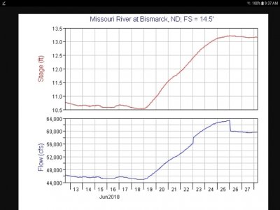
The flow measurements are all human collected, granted they use a lot of high tech stuff nowadays.

Stop referring to it as a "drop" in flow, it's simply within the accuracy of the measurement. There's nothing to be gained by thinking there's actually 3k less cfs in the river, or more for that matter.
 

JayKay

Founding Member
Founding Member
Joined
Apr 20, 2015
Posts
6,729
Likes
440
Points
358
Location
Southeast Bismarck
FWIW, between 9 PM last night and midnight, the river in Bismarck actually went down an inch or two. Saw it with my own eyes.
 

dean nelson

Founding Member
Founding Member
Joined
Jul 17, 2015
Posts
8,270
Likes
66
Points
308
Location
Bismarck
Well you can call it whatever you want but you will find most people generally will call this a drop because well it's sort of you know is a sudden and unexplained drop! It's also interesting now that it's consistently several hundred CFS below what they're letting out not to mention the several tributaries between here in the dam.

Screenshot_20180628-093750.jpg
 

Rowdie

Founding Member
Founding Member
Joined
Apr 15, 2015
Posts
10,040
Likes
1,810
Points
623
We're supposed to have a big storm overnight tonight. What would a quick 5" dō?
 

Allen

Founding Member
Founding Member
Joined
Apr 24, 2015
Posts
10,500
Likes
1,526
Points
628
Location
Lincoln, kinda...
Well you can call it whatever you want but you will find most people generally will call this a drop because well it's sort of you know is a sudden and unexplained drop! It's also interesting now that it's consistently several hundred CFS below what they're letting out not to mention the several tributaries between here in the dam.

th-169.jpg


Without looking, I would guess the equation for the stage-rating curve, which generally goes in the form of "y = mx + b" has been shifted by updating the "b" due to the measurement. This is common, but until someone tells me the physical process by which the river is now losing a couple thousand cfs, I'd suggest the "drop" is not real. Outside of washing machines and dryers, things don't just disappear in real life for no reason. The same organization that is measuring the flow at Bismarck is also measuring the flow immediately below Garrison Dam. Where they maintain there's 60,000 cfs coming out of the dam.


In the initial run up to a new high water mark, there is discharge water lost that is lost to what's called bank storage (water going into the bank and near shore pore space). This doesn't seem to fit that kind of water loss as it's too much and is usually only really observable for the first few days before a new equilibrium with the flood plain aquifer is reached.

I would hazard a guess the true cfs in Bismarck is right around 61,xxx.


rmiller

Member
Joined
Jan 17, 2017
Posts
32
Likes
0
Points
56
Location
Mandan
you all talk a a lot about the river level in Bismarck but I noticed that on the 3 week release forecast Oahe is suppose to rise a foot a week for the next three for a total of 3.5 by the middle of July. As a 3C whitetail doe hunter what will this mean for the prime whitetail habitat south of Bismarck and Mandan along the river. Graner Flooded? Little Heart? and areas south?
 

dean nelson

Founding Member
Founding Member
Joined
Jul 17, 2015
Posts
8,270
Likes
66
Points
308
Location
Bismarck
McLane bottom started flooding the last couple days and much of little Hart is flooded toward to south end. Apple creek bottoms is about 50/50 water land but unlike the others hers is primarily High River Flows there so once they drop river so will she where the other ones are caused more by the back up of water on Oahe with a bit of high River flows added on top. At 1616.5 much of McClain bottoms and Greiner bottoms will be flooded as in years past.
 

eyexer

Founding Member
Founding Member
Joined
Apr 20, 2015
Posts
13,730
Likes
708
Points
428
Location
williston
Think about this. People in LA are smart enough to build their homes 3-4' above the ground. And those are people with no teeth and are married to their sisters. kidding.
 

Migrator Man

★★★★★ Legendary Member
Joined
Feb 3, 2016
Posts
3,961
Likes
22
Points
226
MT is getting pounded today. Not looking good for an already over saturated area.


Obi-Wan

Founding Member
Founding Member
Joined
May 15, 2015
Posts
7,613
Likes
2,746
Points
678
Location
Bismarck
It's a good thing the corp has left enough room in the lake to handle events like this


Recent Posts

Friends of NDA

Top Posters of the Month

  • This month: 109
  • This month: 101
  • This month: 92
  • This month: 82
  • This month: 81
  • This month: 79
  • This month: 74
  • This month: 67
  • This month: 66
  • This month: 66
Top Bottom