Humminbird Auto Chart

Lungdeflator

★★★★★ Legendary Member
Joined
Feb 15, 2017
Posts
1,372
Likes
5
Points
166
Location
Berthold, ND
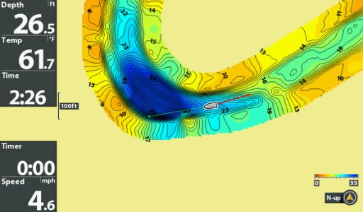
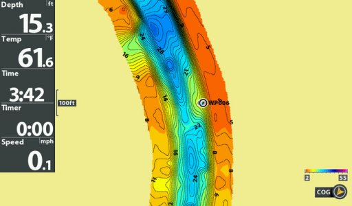
Anybody use the auto chart? Does it work well?

We talked a lot about it on our recent trip up to Canada where there aren't any contour maps. My dad is in the market for a couple new graphs this off season and if the auto chart works well, we will get units capable of it.


zoops

Founding Member
Founding Member
Joined
May 17, 2015
Posts
1,805
Likes
158
Points
278
I've used it for a couple hours; seemed to work well. If you fished a lake a lot it would probably work out but it would take quite a bit of time to survey more than a few dozen acres so if it's just a lake you fish every once in a while maybe not so much. From what I've read you can store 8 hours on the unit itself and past that you need a zero line card from HB. If I remember correctly it used 3-foot contours, so say if you're fishing an area that is 6-10 feet deep it will just mark everything as 6 or 9 feet deep. Pretty sure there are some features you can do with the maps you've created if you upload them to your computer as well.
 

dukgnfsn

Founding Member
Founding Member
Joined
May 9, 2015
Posts
839
Likes
73
Points
223
Location
Bismarck
Funny you should ask, I went to a lake in ND that I figured would be on my chip and it wasn't, so I tried to Hummingbird Auto Chart feature this weekend that afternoon. Used my phone to look at a map off ND G&F for depths. It worked good but the only thing I will say it that it only charts a small zone on each pass and to map that whole lake would take a lot of time so we just charted the areas as we fished and the flat I was fishing didn't have much for depth change or structure so it was a pretty benign looking map but seemed to work very well for first time using it. I still have a lot to learn out these updated units but I did get it to chart dukgnfsn
 

Nmariner

Established Member
Joined
Feb 7, 2017
Posts
135
Likes
4
Points
103
Location
Bismarck
I just started to do this for some ramp less lakes. It looks a little funny having a helix 7 on a $300 john boat lol.

Seems to work well but yes it does take time. You can set the contours to 1' intervals. Looking forward to using the unit ice fishing :)
 

Riverbottoms

★★★★ Legendary Member
Joined
Feb 8, 2016
Posts
496
Likes
3
Points
138
Location
Williston, ND
I used auto chart live a lot this spring fine tuning some sunken islands on the east end of sak. The lake masterchip is pretty nice on sak thou. But if I had to depend on a navaonic map I would catch a lot less fish! Not much detail with navonics. Anyways. I do the love the option of auto chart live feature.


Captainbrad

Founding Member
Founding Member
Joined
Apr 20, 2015
Posts
683
Likes
142
Points
220
Location
Grand Forks
I am a huge huge fan of AutoChart Live. In fact, I believe it is the biggest advancement in electronics of the decade for what I do. I have over 30 miles of the Red done now and will keep building. I find that I use the map more than any other feature of my Helix 10 on some sections of river.

On a side note we used a Helix 7 to map out sections of the lake where we were catching fish on a recent fly in. What we found after a couple of them is what type of structures were holding lake trout then it was a matter of looking for that, map and catch fish. To map each of those spots took about 10 minutes.
 

Attachments

S00190.jpg S00091.jpg

Up Y'oars

Founding Member
Founding Member
Joined
May 16, 2015
Posts
2,261
Likes
59
Points
278
Location
Bismarck
I love Auto Chart Live and use it constantly, but I also have the Zero Lines SD Card. What I don't like about it is having to turn it on every time I power up the monitor. There is only one default setting and that is 'off'. It's frustrating, but there's nothing I can do about it.

Why I like the option is being able to see LIVE contour lines where the mapping cannot determine. Yes, the mapping of the lakes are not what the actual contours actually look like. With Auto Chart you actually get those contours and see a definition of points, ridge lines, etc. that you don't get from the map chip.

I have my Auto Chart set on an overlay setting of 5 so I can see both the map contour lines as well as the actual contour lines. I can then distinguish what is truly below my boat and stay on a point, or cross over a point, that the mapping chip wasn't providing before.

I rank that feature higher on the use scale than down or side scanning.
 

Lungdeflator

★★★★★ Legendary Member
Thread starter
Joined
Feb 15, 2017
Posts
1,372
Likes
5
Points
166
Location
Berthold, ND
It sounds and looks great.

For this particular lake in Canada that we fish, we pretty much have spots figured out, and a basic idea of what they look like. We mark all the spots with GPS, but it still takes a little bit to get on our lines and exactly where we want. So we wouldn't be mapping entire lakes, but smaller spots like reefs and transitions.
 

Recent Posts

Friends of NDA

Top Posters of the Month

  • This month: 104
  • This month: 99
  • This month: 92
  • This month: 82
  • This month: 78
  • This month: 77
  • This month: 74
  • This month: 67
  • This month: 66
  • This month: 66
Top Bottom