ND Oahe Contours

Bfishn

Founding Member
Founding Member
Joined
Dec 7, 2015
Posts
3,862
Likes
274
Points
333
I'm about to buy a Hummingbird Helix 5 for river boat/atv ice fishing. I will mainly be using this on the river/oahe from Bismarck to SD border. When I look at the lake master chips it doesn't say anything about ND Oahe or Missouri river? Is there a good ND Oahe map for the hummingbirds? I don't want to buy it if there isn't.


Bfishn

Founding Member
Founding Member
Thread starter
Joined
Dec 7, 2015
Posts
3,862
Likes
274
Points
333
http://www.humminbird.com/Products/HCDAK5/
think thats about all they offer. dont think it has great detail because of how much it changes every year

Yeah, that's the one I saw but that just says SD Oahe. I thought i had read somewhere that somebody makes a decent chip that goes north to about Hazelton. The question is who and is it compatible with hummingbird.
 

NDwalleyes

Founding Member
Founding Member
Joined
Apr 12, 2015
Posts
2,431
Likes
459
Points
333
Location
Bismarck, ND
Best bet for Oahe is Google Earth...go back and look at old images during the dry years.

You won't find a map of the river...You'll need to figure it out each year. I try to use someone else's boat for the first couple outings.
 

dean nelson

Founding Member
Founding Member
Joined
Jul 17, 2015
Posts
8,270
Likes
66
Points
308
Location
Bismarck
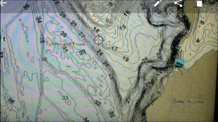
Yeah there is no river chip....well atleast anything remotely accurate. Not sure what one my buddy has but its pretty damn helpful for the ice fishing I've done down there this year.

Screenshot_2016-02-01-18-32-51.jpg


Bfishn

Founding Member
Founding Member
Thread starter
Joined
Dec 7, 2015
Posts
3,862
Likes
274
Points
333
Yeah there is no river chip....well atleast anything remotely accurate. Not sure what one my buddy has but its pretty damn helpful for the ice fishing I've done down there this year.

14317476_10209753914386305_9094908418277672857_n.jpg

That right there is all I'm looking for. Any way to figure out what that is? I get there is no river chip that is accurate but it's nice just to have contours. I can adjust for depth myself. I have a buddy that has an old school gps with countours as well.
 

dean nelson

Founding Member
Founding Member
Joined
Jul 17, 2015
Posts
8,270
Likes
66
Points
308
Location
Bismarck
I will ask him in the morning what chip he has. He definitely needs to lower the elevation some since he has it set damn near to peak 2011 level.
 

dakotaeye29

Founding Member
Founding Member
Joined
Aug 10, 2015
Posts
197
Likes
2
Points
111
I have an older lake master chip for my lowrance, it is fairly accurate from the casino south. Will check to see which one.
 

undguy

Founding Member
Founding Member
Joined
Jul 17, 2015
Posts
111
Likes
8
Points
113
I have a Lakemaster chip in my Humminbird that shows good detail up past Beaver Bay a few miles. Bought chip two years ago.


Bfishn

Founding Member
Founding Member
Thread starter
Joined
Dec 7, 2015
Posts
3,862
Likes
274
Points
333
Thanks guys. Maybe i just need to go down to Scheels and talk to them or see if they will let me look at the Lakemaster chip. I'm assuming even though it says SD Oahe it must extend north to about Beaver? Beaver and south is about all i'm looking for.
 

gone_fishing

Founding Member
Founding Member
Joined
May 15, 2015
Posts
698
Likes
6
Points
158
Location
North Dakota
I have the LakeMaster Dakotas V2.0 chip in my Humminbird. I just looked and it shows contours starting north of the Hazelton boat access (and of course south). I willing to be that this lake was survey before the flood so it's hard to say how accurate it is anymore. Better then nothing I guess.
 

Recent Posts

Friends of NDA

Top Posters of the Month

  • This month: 74
  • This month: 52
  • This month: 50
  • This month: 44
  • This month: 37
  • This month: 34
  • This month: 32
  • This month: 31
  • This month: 31
  • This month: 24
Top Bottom