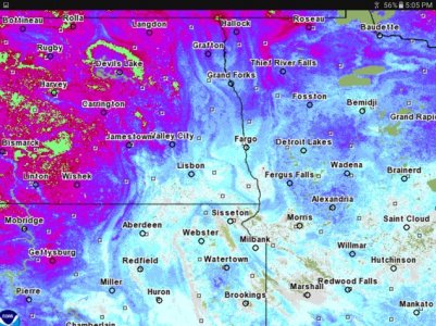
With your guys flood forecast I'm wondering if where the camp is did you guys factor in lake rise on top of river rise or is that more of a Corp thing. Reason I ask is we are currently two feet higher then this point in 11 so have to think we will see if a fair bit of lake rise to go with river rise an that rise if large at all will start pushing into the camp as well even if the cannonball is not all that strong..
You are using an out of date browser. It may not display this or other websites correctly.
You should upgrade or use an alternative browser.
You should upgrade or use an alternative browser.
Hey Alan I have a question for you
- Thread starter dean nelson
- Start date
I heard them say the Red River is expecting to flood AGAIN in the northern tier of ND.
I heard them say the Red River is expecting to flood AGAIN in the northern tier of ND.
Unless we get a lot more snow it will not happen. Ever since 97 they (NWS) is putting the cover your A$$ factor in. Minor flooding YES.
The official NWS forecast location is at Breien. Historical evidence suggests that the flood plain near the mouth is largely wet when the Breien gage reads about 15 ft. Backwater from Lake Oahe can also inundate the area if it gets high enough, but that is not very likely at this point.
Breien has about a 50/50 chance of getting to 15 ft with the current snowpack and near normal moisture going forward.
Breien has about a 50/50 chance of getting to 15 ft with the current snowpack and near normal moisture going forward.
Unless we get a lot more snow it will not happen. Ever since 97 they (NWS) is putting the cover your A$$ factor in. Minor flooding YES.
Just curious here, but would you care to elaborate on what data you base this assessment on?
That would be some interesting data considering how many times I've watched them sandbagging fargo in the years since 97 on the national news!
Be curious to see how much snow this wind event can eat with temps in the mid to upper 30's. Last few days have definitely raised the snowpack temp with it being nearly two days since we dropped below 32 so should at least clear off the ridge lines a fair bit.
Be curious to see how much snow this wind event can eat with temps in the mid to upper 30's. Last few days have definitely raised the snowpack temp with it being nearly two days since we dropped below 32 so should at least clear off the ridge lines a fair bit.
- Joined
- Apr 13, 2015
- Posts
- 8,450
- Likes
- 502
- Points
- 423
Pelican ramp closed for 2017 season.
Well with a 50/50 shot of a three foot rise and a 25% chance of a new record I wouldn't count that chicken before it hatches!
Allen, was that you on KX news talking about Missouri river flooding?
Pelican ramp closed for 2017 season.
The worst flood forecast the weather service has is for Devils Lake, which could see "near record" runoff, consequently rising 3 to 4 feet. The lake level at Creel Bay is now close to 1,450.3 feet above sea level and there is a 25 percent chance it will reach 1,454.3 by the fall. That's a record the lake set in June 2011. There is a 5 percent chance it will reach 1,455.1 feet.
It's going to be a great year for a good old fashion debate for shutting down ND waters during spawning, which we all know won't change a thing cuz we stock our lakes.
The DL basin will have a phenomenal spawn with all that runoff.
:;:exactly
- Joined
- Apr 13, 2015
- Posts
- 8,450
- Likes
- 502
- Points
- 423
idk --when i went up a few weekends ago -- i expected to see snow like bismarck --- wrong --- i seen a lot of open fields with drifts in low spots. With all the rain we got last summer that sucker barely raised the lake. IDK -- we will see what happens -- march and end of feb will tell the tale
- - - Updated - - -
If the lake rises enough and the ramp at Pelican Lake is useable the Fish and Game will put a dock back at that site.
Similar threads
- Replies
- 34
- Views
- 15K
Recent Posts
-
Minn kota I-pilot link swap
- Latest: FightingSioux
-
Oahe report Mobridge
- Latest: LOV2HNT
-
Kristi Noem Dog Killer
- Latest: johnr
-
Representative Dockter
- Latest: Trip McNeely
-
Velocitor V Stinger
- Latest: Lycanthrope
-
Northern Lights
- Latest: SDMF
-
Any Birders here?
- Latest: Davey Crockett
-
Tailrace trout
- Latest: svnmag
-
Sale Marlin 30TK
- Latest: svnmag
-
What are you listening to these days?
- Latest: svnmag
-
This is what its all about
- Latest: wslayer
-
Merino Undies
- Latest: wslayer
-
Buying gold and silver.
- Latest: grumster
-
SOLD Elec Power Washer
- Latest: Zogman
-
What boat ramp open in Bismark
- Latest: Sluggo
-
No Mow May
- Latest: lunkerslayer
-
Tammy Miller
- Latest: Trip McNeely
-
Wild Turkey
- Latest: svnmag
-
Best facebook page ever .
- Latest: Davey Crockett
Friends of NDA
Top Posters of the Month
-
This month: 60
-
- Posts
- 1,046
-
- Likes
- 937
-

