Lake Winnipeg and the Red River are now mapped!

Upnorth

Well-Known Member
Joined
Mar 1, 2017
Posts
77
Likes
12
Points
103
Location
Winnipeg
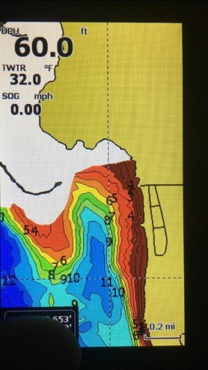
A local company here, AEM mapping, has completed mapping the lower basin of lake winnipeg, from winnipeg beach across to the east side, and down to the mouth of the red river. The lower red river from Lockport to the mouth has also been mapped. The structure they found, and the detail is astounding and will be a game changer, especially for folks coming up and have a limited amount of time to fish. The red is available through hummingbird right now, the AEM maps chips of the red and lake winnipeg are compatable with lowrance units only. A full list of compatable units can be found on their site.
Chips will be available mid December, pricing will be announced shortly.


Bowhunter_24

Founding Member
Founding Member
Joined
Apr 20, 2015
Posts
1,987
Likes
26
Points
241
I’m assuming you work for this company or it’s yours?

I would like some screen shots of this astounding structure they found.
 

Upnorth

Well-Known Member
Thread starter
Joined
Mar 1, 2017
Posts
77
Likes
12
Points
103
Location
Winnipeg
I’m assuming you work for this company or it’s yours?

I would like some screen shots of this astounding structure they found.

nope. Don’t work for them or own the company. Here’s a snapshot from the east side balsam area from last year when they started mapping the south basin. It won’t be released until mid December.
 

Attachments

7F990058-8302-4A6D-98D9-826D7E9348DF.jpg

Recent Posts

Friends of NDA

Top Posters of the Month

  • This month: 73
  • This month: 30
  • This month: 29
  • This month: 28
  • This month: 20
  • This month: 17
  • This month: 15
  • This month: 15
  • This month: 15
  • This month: 14
Top Bottom