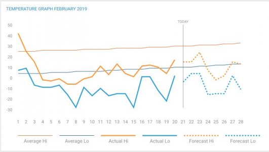
Is it safe to assume we have a higher chance than normal for a heat wave or above normal temperatures during spring thaw this year ? Not sure what side of normal of snowpack the whole state but I'd guess we are already on the + side in my area.
- - - Updated - - -
Glad I live on a hill.
To some extent, yes...I am concerned that the longer we keep going on this below normal temperature pattern and Mother Nature will eventually kick the pendulum to the other extreme. Not necessarily up in your hill country, but down here in the Banana Belt of the state and we are quickly approaching where we are supposed to have a daily high of around 30 degrees. As we sit here 20+ degrees below that average, it is easy to speculate that when the pendulum swings we may be in line for temps of 10-15 above normal. That would be problematic if it happened for a 4-7 day stretch, especially if it came with an inch of rain. The call I put out for soil condition info suggests our snowpack largely sits on very hard ground that would send water running off the countryside just as if it were a Walmart parking lot. The one saving grace we have there is that there aren't a lot of places that have as much snow-water equivalent on the ground as we did back in 2009, which outside of the snow is a decent analog for the temp swing that I'd prefer to not see. A lot of the snow we have came when it was cold out so it didn't/doesn't contain a lot of water.
- - - Updated - - -
Snow-water equivalent (SWE) averaged over large areas from what I can tell:
NW corner of the state = 1.5 - 2 inches this year, which is right about normal.
NC part of the state = 2-3 inches of SWE with the higher values being downstream of Minot and over into the hills.
James River basin = 2-2.5 inches north of Jamestown (about normal), 3-4 south of Jamestown (a little above normal).
Missouri tribs east of highway 83 (Apple and Beaver Creeks) = 2-3 inches of SWE, perhaps a little higher than normal.
Knife River valley = 3-3.5 inches of SWE, a little higher than normal but well short of the 5-6+ it had in 2009 and 2010.
Cannonball R., Heart R. and Cedar Creek are all about normal with 1.5-2.25 inches of SWE. Again, well below values seen in 2009 and even what was present during DAPL where the spring flood failed to show up during a really protracted and gentle early spring melt.
Safe to say the story has not yet been written, but there is cause for concern if you have things too close to a waterway.
- - - Updated - - -
https://www.weather.gov/bis/SpringFloodOutlookForSourisMouseRiverBasin
and
https://www.weather.gov/bis/SpringFloodOutlookForMissouriandJamesRiverBasins
Worthwhile reads if you're concerned about the potential for spring flooding.


