Drain Sakakawea

roosterfish

★★★ Legendary Member
Joined
Dec 25, 2016
Posts
412
Likes
5
Points
128
A stupid question but maybe "Allen" could answer. If they keep releases up like this would it freeze up? Seems like you could put a kayak in at fox island and be at the casino in 10 minutes. It's Rippn!!! And another stupid question. How many days before a flood must you have flood insurance?? asking for a Friend. :;:howdy


undguy

Founding Member
Founding Member
Joined
Jul 17, 2015
Posts
111
Likes
8
Points
113
You build houses in stupid places, you win stupid prizes... Course our tax money will bail everyone out again when it floods. Whoda thunk it?

You are obviously referring to the entirety of south Bismarck. Neither Southport nor Whispering Bay are considered to be in any flood zone. Southport and Whispering Bay were on the wrong side of the dike built by the City with your tax dollars. Not only were they not protected but residents there were assessed for the dike and other flood control costs the same as those on the right side of the dike.
 
Last edited:

Allen

Founding Member
Founding Member
Joined
Apr 24, 2015
Posts
10,515
Likes
1,539
Points
638
Location
Lincoln, kinda...
A stupid question but maybe "Allen" could answer. If they keep releases up like this would it freeze up? Seems like you could put a kayak in at fox island and be at the casino in 10 minutes. It's Rippn!!! And another stupid question. How many days before a flood must you have flood insurance?? asking for a Friend. :;:howdy

30 days before the "declaration" of a flood in progress is the deadline for insurance. Lots of people got waylaid by this in 2011 when they bought insurance in April, got their property wet in June, and were told their insurance wasn't purchased in time because the flood declaration began in April. I am by far an expert on this topic, but I do loosely pay attention.

And yes, even at these flows the river would freeze over under the right conditions. Probably around daytime highs in the lower teens and nighttime lows in the single digits.
 

drayweb

★★★★★ Legendary Member
Joined
Jan 23, 2017
Posts
506
Likes
2
Points
123
Isn't an asphalt backstop a little hard on the arrows?

Actually it was in the open field just south of the parking lot where I shot most of the carp. Put my boat in at Hazelton and went north. Lots of water in 2011.


You

Founding Member
Founding Member
Thread starter
Joined
Apr 30, 2015
Posts
1,467
Likes
30
Points
196
Location
In front.
You, do You have a point in all this? Because, I really am curious.

Just sharing info. I did also sneak a little bit of my opinion in there too with the thread title and leading sentence.

- - - Updated - - -

The guy is just spreading news.

Which is now a foreign concept on NDA. Crazy opinions are what fuels 20 page discussions after all....

FWIW - I would like to share that I have been satisfied with the summer AND fall releases thus far. I don't make it a priority to study the topic, I don't research or necessarily understand their plans of action, I don't compare said plans against historical data, I also haven't researched the maximum sustained outflow the system can handle during the winter months..........NONETHELESS I do have an opinion :;:thumbsup

Send the max from now until the spring 2020 runoff. Drain Sak. And if Dean wants to come on here and say "that's exactly what their doing idiot", I say, great! and let's hold the COE to it.
 

JayKay

Founding Member
Founding Member
Joined
Apr 20, 2015
Posts
6,729
Likes
440
Points
358
Location
Southeast Bismarck
I guess I feel like this is under control, and in the hands of the experts. I've lived in south Bismarck since 1980, and have witnessed one flood event, which actually didn't "get" my parents or my house anyhow. It was close, but didn't get us.

My biggest (tiny) gripe right now is, with the water high like it is, wader fishing has sucked. I'm actually caught up on yardwork, and that's not normal in October and November.
 

Allen

Founding Member
Founding Member
Joined
Apr 24, 2015
Posts
10,515
Likes
1,539
Points
638
Location
Lincoln, kinda...
OK, so if this is intended to be informational, let me chime in here real quick on the status of the Missouri River.

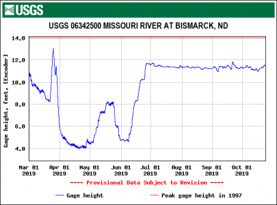
Here's the hydrograph for Bismarck since March 1st of this year.
M.R. 2019.gif.png

Despite being able to keep the Bis/Man area below Flood Stage, you can see they've been running the river pretty high for most of the summer and up to now. While below FS, this does not mean it has been without impacts to people.

The Corps is certainly NOT going to "drain Sakakawea". They are trying to evacuate the stored flood waters and get the entire system down to its 16.X million ac-ft of flood storage, just like they do every year and cause as few of problems doing so as possible. Currently, Sakakawea's share of that puts it at about 1837.5 MSL.

One point to consider here is that if, and that's a big IF, the Corps were to lower the entire M.R. system on a regular basis...then they would not have 16.X million ac-ft of water they needed to get rid of each year, they would have something larger to discharge through the system. In the case of the above hydrograph, the big question you have to answer is where do you squeeze that extra water into the river...knowing there are already impacts at levels seen this year?

If you do it in the months of April and May, you are piling even more water onto what were the flooded areas of SD, IA, NE, MO, etc. I don't think they necessarily would appreciate that. If you did it from July to Oct, that means we would have had to have seen higher water levels here in the ND section of the river, including BisMan. Those that were at the Bismarck meeting the other night already have an idea of some of the impacts felt. If you start getting into the 60,000 cfs range, now you are flirting with Flood Stage here in Bismarck and it's not just groundwater and pastures getting wet, it will be people's yards and homes. If you think we can handle the extra water in the river from now going forward, well...there's this thing called winter that gives riverfront residents a lot of heartburn when they see the river jump up once the ice starts forming a continuous sheet here in the Bismarck area.

So again, I ask the question...who do you want to throw under the bus when it comes to seeing higher water on the river? Is it the downstream people, or your friends and neighbors here in Bismarck/Mandan?

A quick disclaimer here: I do not, in any way, shape, or form have a horse in this race, nor do I have any of the headaches that the Corps has in having to make these tough decisions. I merely work in advertising.
 

guywhofishes

Founding Member
Founding Member
Joined
Apr 21, 2015
Posts
28,714
Likes
4,107
Points
958
Location
Faaargo, ND
hey you guys - don't forget about your better half (Red River communities)

we're headed for our second fall crest... GULP
 
Last edited:


Skeeter

Founding Member
Founding Member
Joined
May 16, 2015
Posts
3,712
Likes
955
Points
403
Location
Beulah nd
hey you guys - don't forget about your better half (Red River communities)

we're headed for our second fall crest... GULP
Drove through minnifornia and your area yesterday. I didn’t feel right until I crossed the river at Bismarck and was back on the west side.

- - - Updated - - -

ha ha ha - ok, ok

- - - Updated - - -

sorry!
On a serious note, I feel for you guys. From Medina all the way to Rogers MN fields are flooded and ditches are full. Rivers are bank to bank and moving fast. The amount of corn and beans left to harvest is astronomical. Pretty scary situation.
 

KDM

Founding Member
Founding Member
Joined
Apr 20, 2015
Posts
9,650
Likes
1,583
Points
563
Location
Valley City
A good friend of my Dad is a big farmer and he told my Dad that they are done trying to harvest. He left thousands of acres of wheat, beans, and corn in the field. The wheat sprouted in the head before they could get it or is flat on the ground, the beans are flooded or you can't get to'em and are so over wet it's ridiculous, and their corn barely if even hit black layer. So with the increased fuel to get at whatever wet beans due to having to go slower, the cost of drying or taking the drying fee hit for the beans and corn, the increased maintenance on equipment from going through mud and dealing with wet grain, and the corn not being mature, they've winterized the equipment and are planning on next spring working everything into the dirt. I know this guy pretty well and hearing this sent a chill to my core. I also know quite a few cattle farmers that lost more than half if not all their hay crop due to rain and or not being able to get at the hay. All this adds up to a big SUCK SANDWICH in my book. NOT GOOD!!
 

Up Y'oars

Founding Member
Founding Member
Joined
May 16, 2015
Posts
2,261
Likes
59
Points
278
Location
Bismarck
There are going to be lots of economical impacts to every citizen in North Dakota, not just the farmers! Prices are going to rise and discretionary spending will likely cease. Every community will feel this pinch. These things don't only affect farm implement dealers, it will affect main street.

I'm in the market for a new 5th wheel camper, but I might hold off to see what happens to the amount of used (new, but sold) campers are out there. In the end I may get a great deal and some rural farmer will get some cash to help turning his situation around.


wslayer

Founding Member
Founding Member
Joined
Jul 12, 2015
Posts
2,307
Likes
449
Points
333
Curiosity;
I'm from the Jmst. area so know we are dealing with high waters from 2 reservoirs here and downstream of the James River. Flew into G.Forks a few weeks, and All you could see for about the last 50 miles was standing water ( I do feel for the farmer with crops yet ). It is inevitable that when we go into freeze up that next spring with the saturated ground, there is going to be a tremendous amount of overland flooding.
My question is, should sandbags be produced now to be used anywhere along the Red, so there isn't such a scrabble come spring time ?
 

628977

Honored Member
Joined
Apr 18, 2016
Posts
273
Likes
29
Points
135
Is there any concern with flushing out the majority of the smelt from Sakakawea with these releases?
 

Allen

Founding Member
Founding Member
Joined
Apr 24, 2015
Posts
10,515
Likes
1,539
Points
638
Location
Lincoln, kinda...
Not that I've heard.

I have heard that some salmon and walleye that were tagged up in Sak have been caught downstream of the dam though.
 

Rowdie

Founding Member
Founding Member
Joined
Apr 15, 2015
Posts
10,090
Likes
1,850
Points
623
I went hunting birds after work last night for the first time. WOW....I've never seen the local corn fields and just plain fields anywhere with standing water in them!! I wouldn't trust driving in a ditch anywhere right now, most have standing water, or saturated. The gravel roads are iffy at best. I did pop one pheasant, missed the first two bigger than life. Dog and I both need to get out more, but gonna have to put on some miles to find dry land. There's going to be A LOT of WASTED CROPS IN THE GROUND!!
 

BDub

Founding Member
Founding Member
Joined
Apr 26, 2015
Posts
2,276
Likes
161
Points
303
Location
Bismarck
Pheasant hunting is going to be a downer this year. Standing crops everywhere and water in every low spot.

North Dakota the land of 1,000,000 sloughs.


Recent Posts

Friends of NDA

Top Posters of the Month

  • This month: 190
  • This month: 153
  • This month: 142
  • This month: 137
  • This month: 113
  • This month: 93
  • This month: 93
  • This month: 88
  • This month: 84
  • This month: 78
Top Bottom