I have added the Navionics mapping into the NDA site.
view here: http://nodakangler.com/forums/content.php?237-navionics
(also linked in sub-nav)
One example of how this can be used below:
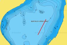
Fished Buffalo Lodge today. Caught our walleye running this pass, at 10-11 fow.

In this scenario, I simply used my print-screen function on my pc, edited the image, and uploaded to this post.
Hopefully this is a useful tool for everyone here on NDA.
When loading the page it defaults to Europe, but just slide the screen to our area. It's easy. I am in contact with Navionics to try and get it to default to ND, and with the satellite overlay default as well. Hopefully soon.
view here: http://nodakangler.com/forums/content.php?237-navionics
(also linked in sub-nav)
One example of how this can be used below:
Fished Buffalo Lodge today. Caught our walleye running this pass, at 10-11 fow.

In this scenario, I simply used my print-screen function on my pc, edited the image, and uploaded to this post.
Hopefully this is a useful tool for everyone here on NDA.
When loading the page it defaults to Europe, but just slide the screen to our area. It's easy. I am in contact with Navionics to try and get it to default to ND, and with the satellite overlay default as well. Hopefully soon.
