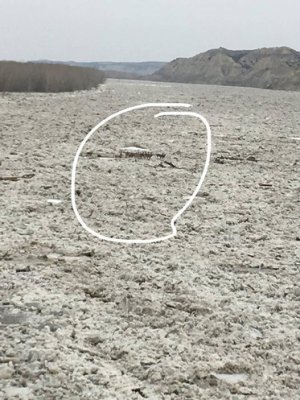
Flooding on the west side.

Brian Renville

Founding Member
Founding Member
Joined
Apr 14, 2015
Posts
4,144
Likes
64
Points
273
Location
Fairview, MT
https://www.facebook.com/richlandde...NL_xrlEKzNiTP2aMl1JsxmR2qailExSwiCYOHxWM0xSZw

- - - Updated - - -
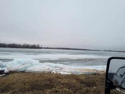
flood.jpg

Confluence


Meelosh

★★★★★ Legendary Member
Joined
Apr 7, 2016
Posts
1,302
Likes
12
Points
171
That area is so prone to ice jams and flooding. Wouldn’t be my first choice for homes/oil wells.
 

Brian Renville

Founding Member
Founding Member
Thread starter
Joined
Apr 14, 2015
Posts
4,144
Likes
64
Points
273
Location
Fairview, MT
Flood damage to homes is far from common around here. Other than a few basements now and then I’ve never actually seen someone lose their house out here even 2011 didn’t destroy houses. Compared to the more talked about areas of ND that have problems seemingly every few years this is very rare. The 30 degree weather has made this pretty ugly. The folks in the house the guy said “evacuated” are fine they just moved things out of the basement in case it gets worse and had a bbq on the approach. Now it’s wait and see. If temps drop more, lookout, I hope they catch a break tonight. Not seeing the sun today hurt the situation big time.
 

Meelosh

★★★★★ Legendary Member
Joined
Apr 7, 2016
Posts
1,302
Likes
12
Points
171
Area around Fairview right? I saw quite a few folks stranded in their homes in 2013 while I was there checking out flooded oil wells. Good to see they didn’t lose their homes but it looked ugly.


Brian Renville

Founding Member
Founding Member
Thread starter
Joined
Apr 14, 2015
Posts
4,144
Likes
64
Points
273
Location
Fairview, MT
Yea February hurt. 3 feet of ice on a river doesn’t mix well with runoff. Haven’t heard anything real bad yet. Mainly some road inconveniences and some freaked out cattle that barely got out in time.

- - - Updated - - -

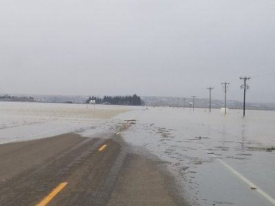
Well it did get worse. Highway 200 is under water and ice. Some dikes broke and it is actually flooding a few folks now. Ish.
 

dean nelson

Founding Member
Founding Member
Joined
Jul 17, 2015
Posts
8,270
Likes
66
Points
308
Location
Bismarck
Any guesses on how high it gets in bismarck? Fox as of a couple hours ago and the current river graph and the Hart river definitely closer to the top of the dikes to make me feel comfortable!.
20190324_153423.jpg

Screenshot_20190324-192451.jpg
Screenshot_20190324-151204_Photos.jpg
 
Last edited:

tikkalover

Founding Member
Founding Member
Joined
May 10, 2015
Posts
8,004
Likes
1,000
Points
483
Location
Minot
Water, where its not supposed to be sucks, When we moved into this house 26 years ago I landscaped the yard to keep water away from the house and haven't had any water in the basement. More importantly did you hit the race and if you did how was fishing. :;:huh
 

DirtyMike

Founding Member
Founding Member
Joined
Apr 13, 2015
Posts
12,068
Likes
378
Points
428
Location
Bismarck, ND
Water, where its not supposed to be sucks, When we moved into this house 26 years ago I landscaped the yard to keep water away from the house and haven't had any water in the basement. More importantly did you hit the race and if you did how was fishing. :;:huh
Nope. Had to babysit the sump pump all weekend. I could have tested deep diver cranks in my backyard.


Brian Renville

Founding Member
Founding Member
Thread starter
Joined
Apr 14, 2015
Posts
4,144
Likes
64
Points
273
Location
Fairview, MT
D19BA289-A05E-447C-AFEC-560FE59013D5.jpeg
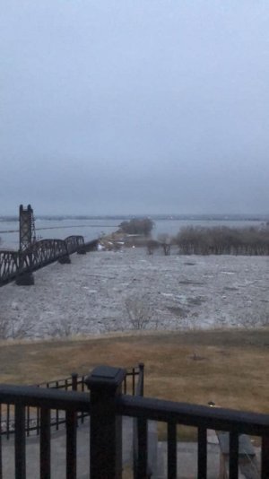
This is on top of the hill at the house at the confluence where you guys paddlefish. That’s a tall cliff that’s completely under and then some.
 

tikkalover

Founding Member
Founding Member
Joined
May 10, 2015
Posts
8,004
Likes
1,000
Points
483
Location
Minot
BISMARCK, N.D. - The Missouri River at Bismarck has risen over four feet in the last few days and is at Action Stage Sunday night.
Action Stage for the Missouri River at Bismarck is 12.5 feet and the river was at 12.73 feet as of 7:15 p.m. CDT., according to U.S. Geological Survey observations.
The National Weather Service says the unusually high water levels are the result of increasing flows from the Knife River, as well as other local tributaries, and impacts of intact ice cover in the Mandan and Bismarck area.
The NWS says damaging high water is not anticipated, however, conditions need to be monitored.
They say ice jams are very unpredictable, but say if intact ice cover begins to break up, it could lead to an ice jam.
 

Obi-Wan

Founding Member
Founding Member
Joined
May 15, 2015
Posts
7,762
Likes
3,080
Points
798
Location
Bismarck
Apple creek is out of its bank down in the wildlife management area and is already over the road by the T. At 3 pm I could drive all the way to the creek but a 7 pm the water was coming over the road by the T
 

dean nelson

Founding Member
Founding Member
Joined
Jul 17, 2015
Posts
8,270
Likes
66
Points
308
Location
Bismarck
Well this isn't weird or anything! So did the river come to some unbelievably stable magic level or do we somehow have synchronized gauge failures?

Screenshot_20190325-081527.jpg

Screenshot_20190325-081350.jpg


Brian Renville

Founding Member
Founding Member
Thread starter
Joined
Apr 14, 2015
Posts
4,144
Likes
64
Points
273
Location
Fairview, MT
A4EB0EDC-631B-4AB5-98F9-BCDAA3898B19.jpeg
Taked this morning at 6:30. This is insanity that water goes from Sundheim park miles toward Fairview.

- - - Updated - - -

Here is a video of ND HWY 200, the water is flosing from north to south(the river flows north here). The bluffs in the distance is where the river is(normally).

https://www.facebook.com/brett.berry.5070/posts/2794779173895716

- - - Updated - - -

flood2.jpg

This pic was taken on hwy 200 about 3 miles from where the river normally is.


Recent Posts

Friends of NDA

Top Posters of the Month

  • This month: 76
  • This month: 55
  • This month: 52
  • This month: 44
  • This month: 37
  • This month: 35
  • This month: 32
  • This month: 31
  • This month: 31
  • This month: 24
Top Bottom