Missouri River rise

Obi-Wan

Founding Member
Founding Member
Joined
May 15, 2015
Posts
7,784
Likes
3,134
Points
798
Location
Bismarck
full.php

What does that equate to in actual water?

Why the big difference between yours & my link?
 
Last edited:


BRK

★★★★★ Legendary Member
Joined
Dec 22, 2016
Posts
1,062
Likes
68
Points
208
Has Nean Delson weighed in recently? I'd be curious to hear his opinion.
 

Allen

Founding Member
Founding Member
Joined
Apr 24, 2015
Posts
10,555
Likes
1,597
Points
638
Location
Lincoln, kinda...
What does that equate to in actual water?

Why the big difference between yours & my link?

You can go to weather.gov/billings and navigate your way to the AHPS page, from there you can click on the precipitation mapping tab and plot it in a number of different ways.

You posted snotel's estimate for how much water in the snowpack was left as a percent of normal for that day in history. I posted a map showing the 300-600 percent of normal rainfall received over the past 30 days, as you requested.
 

Nean Delson

Active Member
Joined
Aug 26, 2016
Posts
69
Likes
7
Points
85
Has Nean Delson weighed in recently? I'd be curious to hear his opinion.

I'm here! I'm letting my brother take over this thread. As he does most of the time. He's a pro!

Lesson learned? Flooding is bad. MMmmkay?


Obi-Wan

Founding Member
Founding Member
Joined
May 15, 2015
Posts
7,784
Likes
3,134
Points
798
Location
Bismarck
You can go to weather.gov/billings and navigate your way to the AHPS page, from there you can click on the precipitation mapping tab and plot it in a number of different ways.

You posted snotel's estimate for how much water in the snowpack was left as a percent of normal for that day in history. I posted a map showing the 300-600 percent of normal rainfall received over the past 30 days, as you requested.

My recent link was NWS Great Falls precipitation totals which includes month to date, calendar year, and water year as of june 24th and it does show a few totals in the low 200's it does not show any in the 300 plus.


http://www.wrh.noaa.gov/tfx/dx.php?wfo=tfx&type=&loc=products&fx=PCPNTOTALS
 
Last edited:

Allen

Founding Member
Founding Member
Joined
Apr 24, 2015
Posts
10,555
Likes
1,597
Points
638
Location
Lincoln, kinda...
That I can't answer for you, other than this isn't a Great Falls area problem. It's been a Billings problem until last week when Great Falls seemed to get jealous and kick it in gear.
 

Obi-Wan

Founding Member
Founding Member
Joined
May 15, 2015
Posts
7,784
Likes
3,134
Points
798
Location
Bismarck
That I can't answer for you, other than this isn't a Great Falls area problem. It's been a Billings problem until last week when Great Falls seemed to get jealous and kick it in gear.

Did you look at it Billings in included? Doesn't this represent the entire state of Montana?
 

Allen

Founding Member
Founding Member
Joined
Apr 24, 2015
Posts
10,555
Likes
1,597
Points
638
Location
Lincoln, kinda...
Did you look at it Billings in included? Doesn't this represent the entire state of Montana?

Ah, so it does. The posted image I used is the past 30 days. While it would still seem there's a bit of a leap between the two, yours uses current month (from the 1st to whatever day it's posted), from first of year to now, and from beginning of water year (Oct 1) to now statistics. So they are not perfect comparisons except for the first day of the month on a 30-day month where mine would be using the previous day and the 29 days ahead of it. And, of course, the one I use it also RADAR enhanced where yours is strictly as measured on the ground (granted, there could be missing days of info at any of those sites).
 

dean nelson

Founding Member
Founding Member
Joined
Jul 17, 2015
Posts
8,270
Likes
66
Points
308
Location
Bismarck
And the arrival of 10 million mosquitoes in 3. 2. 1. Definitely lots of carp in there for the shooting.


Screenshot_20180626-095150.jpg


Paddledogger

★★★★★ Legendary Member
Joined
Mar 22, 2016
Posts
1,052
Likes
106
Points
248
Location
SW ND

Obi-Wan

Founding Member
Founding Member
Joined
May 15, 2015
Posts
7,784
Likes
3,134
Points
798
Location
Bismarck
I noticed a tad bit of a difference on some Corp information of inflow and outflows based on projections on June 22 and data from today.

http://www.nwd-mr.usace.army.mil/rcc/reports/twregfcast.pdf This one shows inflow was estimated to be 81,000 cfs with outflow 60,000 cfs.

http://www.nwd-mr.usace.army.mil/rcc/nwo/dailybull.pdf This one shows inflow is 91,000 cfs with outflow 60,100 cfs.

I sure would think that 10,000 cfs inflow difference is pretty substantial to me.
I have the forecast from 6/20/18 which shows the projected inflows for 6/26/18 at 76,000 and outflows at 60,000 so their projection a week ago for today was 15,000 cfs short I see the new report also has outflows at 60,000 through 7/19/2018 and on the 6/20/18 forecast they were going to start backing off on 7/11/18

The corp seems to run the system like a kid with his money living pay check to pay check instead of saving for a rainy day


JayKay

Founding Member
Founding Member
Joined
Apr 20, 2015
Posts
6,729
Likes
440
Points
358
Location
Southeast Bismarck
I noticed a tad bit of a difference on some Corp information of inflow and outflows based on projections on June 22 and data from today.

http://www.nwd-mr.usace.army.mil/rcc/reports/twregfcast.pdf This one shows inflow was estimated to be 81,000 cfs with outflow 60,000 cfs.

http://www.nwd-mr.usace.army.mil/rcc/nwo/dailybull.pdf This one shows inflow is 91,000 cfs with outflow 60,100 cfs.

I sure would think that 10,000 cfs inflow difference is pretty substantial to me.

I'm confused. Your first chart is the same one that I've been kinda watching. If you are talking about what goes IN to Sak, then it's 85,400 cfs. with 60,000 coming out, right? They are "off" by 5600 cfs.

I know it's not over yet, but it appears that the peak has been reached.

Or that may be wishful thinking. I'm no expert. I'm not complaining though.
 

BrokenBackJack

Founding Member
Founding Member
Joined
May 13, 2015
Posts
9,225
Likes
4,706
Points
773
Location
Central, AZ
Talking big bad storms possible tomorrow ( Thursday ) afternoon. 70 mph winds, rain, hail, and tornado's possible.
 

BRK

★★★★★ Legendary Member
Joined
Dec 22, 2016
Posts
1,062
Likes
68
Points
208
Forced me to take a day off tomorrow to move my camper for the 4th in the morning/early afternoon instead of evening... not that I mind a day off at the lake setting up camping for the 4th so it's a win/maybe win so long as it doesn't get too nasty!
 

Obi-Wan

Founding Member
Founding Member
Joined
May 15, 2015
Posts
7,784
Likes
3,134
Points
798
Location
Bismarck
Corp daily bulletin has 98,000 coming into the lake which is up from yesterdays 91,000 with releases at 60,100. The releases from Fort Peck are 20,400 and the Yellowstone flowing through Sidney Montana are 57,895 ( down about 2,000 from yesterday ) but if I add the two that is 78,295 so somewhere along the line they say we are picking up just shy of 20,000. On 6/20 they predicted 76,000 for inflows for Garrison and on 6/26 they predicted 82,300 inflow for Garrison.
 

dean nelson

Founding Member
Founding Member
Joined
Jul 17, 2015
Posts
8,270
Likes
66
Points
308
Location
Bismarck
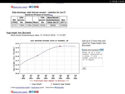
Well remember just a bit ago when I was asking about the 2500 to 2800 Surplus we are running each day through town here above the actual release amount? Well now somehow we've magically gone to a couple hundred deficit which is fairly impressive and theoretically impossible unless we have the most insane evaporation amount ever.

Screenshot_20180627-114213.jpg


Recent Posts

Friends of NDA

Top Posters of the Month

  • This month: 98
  • This month: 72
  • This month: 58
  • This month: 54
  • This month: 48
  • This month: 46
  • This month: 41
  • This month: 34
  • This month: 33
  • This month: 29
Top Bottom