Question of Devils Lake elevation pits farming versus fishing

espringers

Founding Member
Founding Member
Joined
May 18, 2015
Posts
8,222
Likes
947
Points
438
Location
Devils Lake
Hey dean, no need to be a Richard. I am very aware of the concerns, treaty, biota, etc... But, the contention that the desire for a somewhat stable devils lake puts me on a different planet is short sighted. A dry Lake bed is something this region doesn't ever want to see again. And geologically speaking, that was just yesterday. Stability in one way, shape or form is certainly desirable from many perspectives. Doesn't necessarily have to be Missouri water. Ain't sure what the other options are though. And just cause you get water to the faucet, doesn't mean you have to turn the faucet on. It would only be turned on in times of extreme drought.

- - - Updated - - -

And the lawsuits from locals is a non issue. Similar shit has been done all over the country for decades. Legit water projects clearly fall under eminent domain. You pay them for their loss and move on. The biota issue and Canadian and/or mn lawsuits are the major hurdle. Nobody disputes that. It's what's stood in our way for decades.
 
Last edited:


dean nelson

Founding Member
Founding Member
Joined
Jul 17, 2015
Posts
8,270
Likes
66
Points
308
Location
Bismarck
Oh I don't care about fargo getting water from here its impact would be less then one half of one percent of the water that river moves.

- - - Updated - - -

Hey dean, no need to be a Richard. I am very aware of the concerns, treaty, biota, etc... But, the contention that the desire for a somewhat stable devils lake puts me on a different planet is short sighted. A dry Lake bed is something this region doesn't ever want to see again. And geologically speaking, that was just yesterday. Stability in one way, shape or form is certainly desirable from many perspectives. Doesn't necessarily have to be Missouri water. Ain't sure what the other options are though. And just cause you get water to the faucet, doesn't mean you have to turn the faucet on. It would only be turned on in times of extreme drought.

- - - Updated - - -

And the lawsuits from locals is a non issue. Similar shit has been done all over the country for decades. Legit water projects clearly fall under eminent domain. You pay them for their loss and move on. The biota issue and Canadian and/or mn lawsuits are the major hurdle. Nobody disputes that. It's what's stood in our way for decades.

Your talking about places like valley city, fargo, grand forks and so on. They are not going to risk billions in damage so people up there have a stable water level. The risk reward is far to steep to make politicians interested it being associated with it. It's a nice dream but that's all it is. It doesn't matter what they did in the past because that's not the way it is done now. Can you imagine what it would be like building the garrison dam now....it just wouldn't happen. hell nd newest reservoir was stuck in government red tape for decades and that thing it tiny!
 

3Roosters

Founding Member
Founding Member
Joined
Jul 21, 2015
Posts
4,729
Likes
730
Points
343
Location
Devils Lake
One thing is fairly certain of the Federal Govt. A study would have to be conducted to study the study of the study that studied this situation long ago. Once that study is completed, another study will have determine if said study is legit or not and if not, would have to initiate another study to replace the afore mentioned illegitimate study. All the while, said study makers get re elected to continue studying.;:;banghead
 

dean nelson

Founding Member
Founding Member
Joined
Jul 17, 2015
Posts
8,270
Likes
66
Points
308
Location
Bismarck
One thing is fairly certain of the Federal Govt. A study would have to be conducted to study the study of the study that studied this situation long ago. Once that study is completed, another study will have determine if said study is legit or not and if not, would have to initiate another study to replace the afore mentioned illegitimate study. All the while, said study makers get re elected to continue studying.;:;banghead
Maybe they could claim that the water in the Missouri feels like its really red river water from birth and should be treated as such. That argument seems to work in Washington.


lunkerslayer

Founding Member
Founding Member
Thread starter
Joined
Apr 12, 2015
Posts
19,138
Likes
3,147
Points
858
Location
Cavalier, ND
OK how is it possible to bring water from one state to another example? Colorado to California

Update: the boat launch off of highway 57/20 adjacent to the stromme addition is not usable. Someone has blocked the access with the dock sections.
 
Last edited:

dean nelson

Founding Member
Founding Member
Joined
Jul 17, 2015
Posts
8,270
Likes
66
Points
308
Location
Bismarck
First off unaware of any pipe or canal between the state of California and colorado. The main reason is they were put in before the hyper strict rules were put into place. Like I said if it treated and the feds are okay with it you can move water anywhere. But the feds don't like the red river project for some reason....probably Canada bitching.
 

PrairieGhost

Founding Member
Founding Member
Joined
May 15, 2015
Posts
10,397
Likes
825
Points
493
Location
Drifting the high plains
Allen, sorry I can't quote your post, or cut and paste. I am glossing for bear and only get one bar on the phone.

Anyway in answering to your treaty question, it's the 1909 International Boundary Waters Treaty Act. It was a point of contention haunting Garrison Diversion. Transferring Biola from the Gulf of Mexico watershed to the Hudson Bay water shed carries the same danger as small pox from Europe to the native Americans.
 

lunkerslayer

Founding Member
Founding Member
Thread starter
Joined
Apr 12, 2015
Posts
19,138
Likes
3,147
Points
858
Location
Cavalier, ND
So I was doing a little more digging on the MCclusky canal which is maybe 2 miles from Sheyenne river which feeds into a bunch of chain lakes where the last one is the coal mine lake. The New Rockford canal which is 18 miles away for the end of the MCclusky canal. All this tells me one thing that the project is doable if the federal government as well as the EPA can approve of this completion to the eastern part of the state. If the oil prices rebound ND could see this proposal back on the table of discussion. I would love to see the canal come to the basin where it can be utilized for growth in the eastern part of the state by means of more canals.

Also I do believe they were trying to keep the water from going directly into the Sheyenne river because there is a spot on the map that show the channel and the river parallel to each other.
 
Last edited:

shorthairsrus

Founding Member
Founding Member
Joined
Apr 13, 2015
Posts
8,463
Likes
505
Points
423
Lunker that access was usable with alot less water. I used it back in the 90s. One o them goes deep


lunkerslayer

Founding Member
Founding Member
Thread starter
Joined
Apr 12, 2015
Posts
19,138
Likes
3,147
Points
858
Location
Cavalier, ND
Lunker that access was usable with alot less water. I used it back in the 90s. One o them goes deep


This one
Capturestromme.jpg
 

shorthairsrus

Founding Member
Founding Member
Joined
Apr 13, 2015
Posts
8,463
Likes
505
Points
423
those are good yet -- I bet they are doing maintenance.

- - - Updated - - -

or when they raised them - they took out the lower portion.
 

lunkerslayer

Founding Member
Founding Member
Thread starter
Joined
Apr 12, 2015
Posts
19,138
Likes
3,147
Points
858
Location
Cavalier, ND
ok well I hope so because that is the only public access on that side of the 20 bridge
 

shorthairsrus

Founding Member
Founding Member
Joined
Apr 13, 2015
Posts
8,463
Likes
505
Points
423
Lunker now you have my curiosity up --- so I looked at the boat ramp status --- when you see bottom of 1442. Does that indicate that at 1442 the last piece of cement is out of the water or does it indicate that you can still put in as long as the water is at 1442?


lunkerslayer

Founding Member
Founding Member
Thread starter
Joined
Apr 12, 2015
Posts
19,138
Likes
3,147
Points
858
Location
Cavalier, ND
Lunker now you have my curiosity up --- so I looked at the boat ramp status --- when you see bottom of 1442. Does that indicate that at 1442 the last piece of cement is out of the water or does it indicate that you can still put in as long as the water is at 1442?
I drove by the ramp and they had the docks blocking the access so no one could launch their boats, so as far as that elevation I could not tell you other than what I saw today.
 

dean nelson

Founding Member
Founding Member
Joined
Jul 17, 2015
Posts
8,270
Likes
66
Points
308
Location
Bismarck
So I was doing a little more digging on the MCclusky canal which is maybe 2 miles from Sheyenne river which feeds into a bunch of chain lakes where the last one is the coal mine lake. The New Rockford canal which is 18 miles away for the end of the MCclusky canal. All this tells me one thing that the project is doable if the federal government as well as the EPA can approve of this completion to the eastern part of the state. If the oil prices rebound ND could see this proposal back on the table of discussion. I would love to see the canal come to the basin where it can be utilized for growth in the eastern part of the state by means of more canals.

Also I do believe they were trying to keep the water from going directly into the Sheyenne river because there is a spot on the map that show the channel and the river parallel to each other.
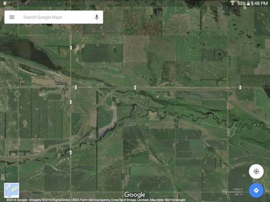
First off just know I'm not trying to come off as a dick here ...and just because I'm talking about why the canal won't work doesn't mean your dream scenario isn't the same one I have as well. The last point is simply the canal is more or less finished long ago all the way till just after it crosses the Continental Divide for the second time north east of New Rockford The paralleling along the river is true but if you look closer you will see the the river you speak off is not the Sheyenne but in fact the James. The coal mine lake you mentioned is the headwaters of the sheyenne and is the lonetree I spoke of earlier. They split the canal off of the james side of the divide just a few miles east of lonetree after mixing the two which is a problem. At which point they literally had to put in an overpass for the water to clear the james as you can see in the pic below. Side note here....why didn't they just start the new Rockford leg of the Canal at this point instead of a few miles back costing millions and millions of dollars to build a short length of canal thats seems quite pointless.

Screenshot_2016-04-26-21-48-03.jpg


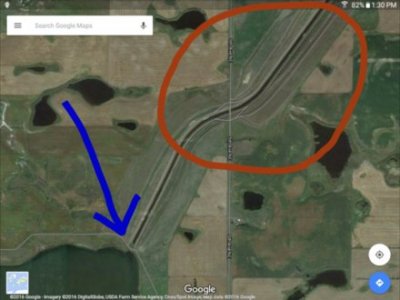
The canal was built up enough to work long ago but so was the battle that shut it down in the first place around 30 years ago. In the end if the other side was able to shut it down that many years ago when lawyers and ANS had little impact on most projects can you imagine the insane level of red tape both nationally and internationally that this would create. This pic is the telling point I'm trying to convey here in that they won't cross the divide in the modern world so much so they block it off to stop it The red circle is the divide (i circled it instead of putting a line in because theres a small low spot there that splits the two ridge lines at 1,900 feet. To the left you will see a dike they put in so no water could free flow past that point. I have a sneaking suspicion that that location was not chosen arbitrarily but in fact to keep the two basins separate.

2016-04-26 13.31.24.jpg
 
Last edited:

lunkerslayer

Founding Member
Founding Member
Thread starter
Joined
Apr 12, 2015
Posts
19,138
Likes
3,147
Points
858
Location
Cavalier, ND
I don't understand the continental divide becuase it goes into the Hudson Bay instead of the Gulf Mexico
 

PrairieGhost

Founding Member
Founding Member
Joined
May 15, 2015
Posts
10,397
Likes
825
Points
493
Location
Drifting the high plains
Huh......? Its gulf of Mexico water you want to move into hudson bay watershed.
It's been a long time since I have given this any attention. The original plan was to run Missouri water into Devils Lake, through to Stump Lake, and then dump into the Sheyenne River. It's the biota from a totally different watershed that Canada objected to. I believe there was a treaty signed in 1914 against such things as this water into the Sheyenne. Since it's from a different watershed with a great geographic separation there could be organisms as destructive to their fisheries as small pox was to the native Americans.
I realize you ended your sentence with a period not a question Dean, just confirming.
 
Last edited:


Recent Posts

Friends of NDA

Top Posters of the Month

  • This month: 229
  • This month: 192
  • This month: 91
  • This month: 88
  • This month: 82
  • This month: 82
  • This month: 78
  • This month: 68
  • This month: 65
  • This month: 59
Top Bottom