Question of Devils Lake elevation pits farming versus fishing

Davey Crockett

Founding Member
Founding Member
Joined
Apr 22, 2015
Posts
13,801
Likes
1,282
Points
563
Location
Boondocks
I wonder what the salt content is now days ? Has to be way less with the big flush but I suppose with all the water to soil contact area it picks it up ?? I shouldn't have started reading and thinking about this , It's turning into a mystery, One that is still in the making.
One of the next couple of snow storms we get I'll have to read up on it and ask more questions on here. :;:sorry


dean nelson

Founding Member
Founding Member
Joined
Jul 17, 2015
Posts
8,270
Likes
66
Points
308
Location
Bismarck
I know when I took a corse in college on devils lake (yes that was a rell thing and a full semester at that) that pre 93 salt content was so high on the east end that most fish could not successfully spawn on that end. Over many years as new water would come in from the north west it would slowly move that way evaporating as it went thus becoming salter as it moved east. With new water coming in at such a high rate and the big flush that happend when stump filled it's greatly reduced the salt levels.

- - - Updated - - -

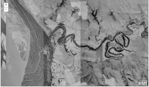
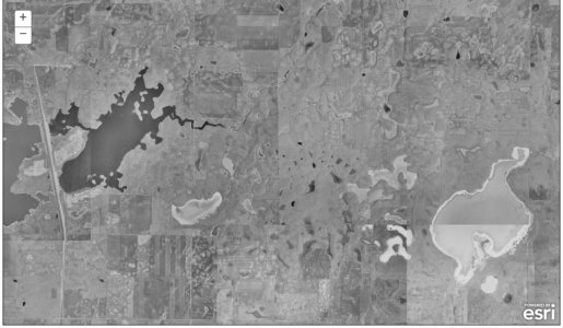
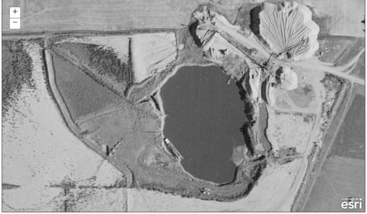
My God am I in love with that map you posted!!! A few of my favorites sofar.

Beaver bay pre lake oahe.

20170220_223130.jpg

Lake Audubon before filling all the way.

20170220_223156.jpg

Cottonwood Lake in Bismarck the lake i grew up on as a gravel pit. For the record I've tried to find pics of it when it was a gravel pit but this is the first one Ive ever seen so thank you for that. It definitely answers the question I've always had on why we have a sand bar on one side.

20170220_223238.jpg
 

Davey Crockett

Founding Member
Founding Member
Joined
Apr 22, 2015
Posts
13,801
Likes
1,282
Points
563
Location
Boondocks
Yea it's a cool old map, I'm pretty sure there is another one from the very late 60s or early 70s . I have a big wall map/photo of the farm from that era. The 57-62 map is sketchy around some of the water areas like it is overlay or double exposure, Not sure what/why that is.

- - - Updated - - -

Yes out where East Devils Lake is you would have to drill for water in 1957. There were a number of gas station, even a Dairy Queen type store on the west side of the highway in 1957. My old brain can't remember right now the name of the old fellow who had a store where the casino is now.
In 1957 air photos were taken of all of North Dakota and many other states. It's how we identify wetlands now long gone.


PG old timer, I have a question, Do you remember what the name of the little old Grahams Island bait shop ? It was owned by two brothers , Were they the Grahams ? I don't even know why I need to know but it bugs me that I can't remember. They were nice old guys to BS with and would always put a guy on fish.

- - - Updated - - -

PrairieGhost; My Grandfather rode this to Devils Lake:[ATTACH=CONFIG said:
17031[/ATTACH]

http://tourism.devilslakend.com/what-to-do/explore-history/minnie-h/

I believe he said it went from Ft. Totten, to Minnewaukan, to Churches Ferry, to Devils Lake. It actually sounded to me like the lake was much larger then than now. Not much draft on that boat I wouldn't have wanted to be on that lake in a wind. As I understand the original name was Minnewaukan meaning Spirit Water, not Devils Lake. Named for a bunch of native Americans that drown on the lake. Couldn't resist a little history.
attachment.php


It would be fun to know where the ports were and go diving for coins and other treasures.
 

lunkerslayer

Founding Member
Founding Member
Thread starter
Joined
Apr 12, 2015
Posts
19,053
Likes
3,062
Points
858
Location
Cavalier, ND
Its strange that gis file wont let you zoom in to certain areas of devils lake but will on others. HMMMMM?
 
Last edited:

dean nelson

Founding Member
Founding Member
Joined
Jul 17, 2015
Posts
8,270
Likes
66
Points
308
Location
Bismarck
Yea it's a cool old map, I'm pretty sure there is another one from the very late 60s or early 70s . I have a big wall map/photo of the farm from that era. The 57-62 map is sketchy around some of the water areas like it is overlay or double exposure, Not sure what/why that is.

- - - Updated - - -


PG old timer, I have a question, Do you remember what the name of the little old Grahams Island bait shop ? It was owned by two brothers , Were they the Grahams ? I don't even know why I need to know but it bugs me that I can't remember. They were nice old guys to BS with and would always put a guy on fish.

- - - Updated - - -

attachment.php


It would be fun to know where the ports were and go diving for coins and other treasures.

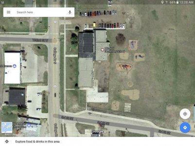
The boat was the minnie H and the schools name is not an accident. Some historians say the dock was closer to the meat market on the lower left of this pic well some say it was where the school now is. Either way it's splitting hairs with how close they are. I remember going by there as a kid and hearing the story of the steam ship and thinking they were lying.

Screenshot_20170221-002853.jpg


Davey Crockett

Founding Member
Founding Member
Joined
Apr 22, 2015
Posts
13,801
Likes
1,282
Points
563
Location
Boondocks
this is all interesting reading...

i think i've written on here b4 that some are now wondering if this is the norm and the recent dry cycle was exactly that, a dry cycle... my mom and dad talked about the rains starting one fall in the mid 60's, and them getting most of the equipment out of the lake bottom between lakes alice and ervine... they had to leave 1 or 2 pieces there because the rains came that fall, and they haven't seen the sun since...

imagine the whole basin b4 the road grid was established and ag ruled for a 1/2 century of drought...


Was there any buy out or compensation for farmers back then ? Is there now ?
 

shorthairsrus

Founding Member
Founding Member
Joined
Apr 13, 2015
Posts
8,444
Likes
494
Points
393
The norm isn't normal. Every farmer now normally drains his field hence now we have a new norm.
 

espringers

Founding Member
Founding Member
Joined
May 18, 2015
Posts
8,189
Likes
895
Points
428
Location
Devils Lake
Shorthairs, then how do you explain the ferry running from about where the law enforcement center is now all the way to churches ferry? Was that not normal before the new normal or normal before the now unnormal? I know drainage has an affect on that basin. But, it gets way over played in times of high water like now imho.


lunkerslayer

Founding Member
Founding Member
Thread starter
Joined
Apr 12, 2015
Posts
19,053
Likes
3,062
Points
858
Location
Cavalier, ND
I stumbled across this map, It's a treasure. I'm amazed at the quality based on the time period it was made and considering pictures were developed in a darkroom back then. It must have taken 5 years to photograph the state from 1957-1962 Fun looking at the changes that have occurred over the years, The ponds up here were drier than I can ever remember them. Devils lake was way smaller .


https://ndgishub.nd.gov/arcgis/rest/services/Imagery/AerialImage_ND_19571962/ImageServer?f=jsapi

This gis file is amazing this shows the original hwy2 route, it's shows how 20 and 19 intersect the college drive under pass, also it shows in Walhalla where my dad grewup where the house was not built yet.
 
Last edited:

PrairieGhost

Founding Member
Founding Member
Joined
May 15, 2015
Posts
10,369
Likes
770
Points
483
Location
Drifting the high plains
But, it gets way over played in times of high water like now imho.
Well if you consider my cousins field, right along channel A, blowing away in the wind while the lake floods it makes you scratch your head. This lake has been much higher before any drainage occurred. However what we consider high water in realits is nothing compared to high precipitation weather patterns of the past. Looking at geographic evidence of weather patterns we have seen nothing yet. People don't live long enough to see longer term weather shifts. That makes people think we areally in a wet period. Within the past 100 years that would be correct. Drainage with the precipitation we have had contributed greatly. It's just masked by a short term wet period, but within a longer term dry period. There is geological evidence that we are near the end of a 400 year extremely dry period. (Personal communication with geologists out of Denver and PhD student out of the University of Minnesota).
 

Farm boy

New member
Joined
Feb 21, 2017
Posts
2
Likes
0
Points
51
Location
North central ND
I have a question that possibly has been asked before but I am curious if the Devils Lake dike was removed at what elevation would the lake be at?The old elevations are with it out and acre area would change at this current elevation.
 

lunkerslayer

Founding Member
Founding Member
Thread starter
Joined
Apr 12, 2015
Posts
19,053
Likes
3,062
Points
858
Location
Cavalier, ND
Well if you consider my cousins field, right along channel A, blowing away in the wind while the lake floods it makes you scratch your head. This lake has been much higher before any drainage occurred. However what we consider high water in realits is nothing compared to high precipitation weather patterns of the past. Looking at geographic evidence of weather patterns we have seen nothing yet. People don't live long enough to see longer term weather shifts. That makes people think we areally in a wet period. Within the past 100 years that would be correct. Drainage with the precipitation we have had contributed greatly. It's just masked by a short term wet period, but within a longer term dry period. There is geological evidence that we are near the end of a 400 year extremely dry period. (Personal communication with geologists out of Denver and PhD student out of the University of Minnesota).

Pg YOU have some litature of what you are referring to
 

Captain Ahab

Founding Member
Founding Member
Joined
Apr 22, 2015
Posts
10,532
Likes
446
Points
428
Location
Timbuktu
I have a question that possibly has been asked before but I am curious if the Devils Lake dike was removed at what elevation would the lake be at?The old elevations are with it out and acre area would change at this current elevation.

We'd be bouncing lures off everything except the downtown area up on the hill.


remm

Founding Member
Founding Member
Joined
May 18, 2015
Posts
1,129
Likes
59
Points
213
Location
Devils Lake
Yep, dam near everything in town other than downtown is well below the current lake level. Has been for quite a while actually. The dyke/dam at north end of creel bay- now called the Henegar boat landing- has been holding water back from the town for quite some time. Of course now that dyke has been extended around much more of creel bay, but it used to be a fairly small rock dam.


We'd be bouncing lures off everything except the downtown area up on the hill.
 

lunkerslayer

Founding Member
Founding Member
Thread starter
Joined
Apr 12, 2015
Posts
19,053
Likes
3,062
Points
858
Location
Cavalier, ND
I have a question that possibly has been asked before but I am curious if the Devils Lake dike was removed at what elevation would the lake be at?The old elevations are with it out and acre area would change at this current elevation.
I am not sure of the numbers exactly but it was determined that Devils Lake would have been between 6 to 12 feet of water across Devils lake. That was based on the assumption that the water would have never had flown into stump lake. I could see Devils Lake had a moat long ago it makes since looking at the topography of the basin since the town of Devils Lake is on a hill top with a lot of lower area especially where Walmart and the DL lagoon areas are now. They said Walmart parking lot would have been at least 10 feet or more.
 

espringers

Founding Member
Founding Member
Joined
May 18, 2015
Posts
8,189
Likes
895
Points
428
Location
Devils Lake
i think what he really wants to know is: if we got rid of the dike and let the water spread out naturally, how much would the lake level drop overall? i have no answer to that. i suspect it might not be real easy to determine for us regular folk. but, it would involve taking the current acre-foot number, removing the dike for imaginary purposes and seeing how much land that same amount of water would cover and taking a new elevation.

to determine the answer to the question of how much of the city of devils lake will be under water at the current elevation, one really only needs to look at google earth or a good topo map i think.
 

lunkerslayer

Founding Member
Founding Member
Thread starter
Joined
Apr 12, 2015
Posts
19,053
Likes
3,062
Points
858
Location
Cavalier, ND
I was always amazed at the current around the bridges even when it was fairly calm there was a current between 57 and the 20 bridges. I never fished six miles as often when I was a kid. The 57 bridge at around 1988 was maybe 8 feet deep all sandy bottom. We would come up to fish during the fourth of July. You could fish the current as a group the farthest from the bridge would cast the farthest left or right depending on the current . Then the next would cast the the next and so on. The best time was when the current stopped for a few minutes the feed was on .
Anyways I have a theory on the current it could be explained as tub filled with couple inches of water then you lift up one side then lift the other causing the water to flow back and forth.
Any ideas
 
Last edited:

Davey Crockett

Founding Member
Founding Member
Joined
Apr 22, 2015
Posts
13,801
Likes
1,282
Points
563
Location
Boondocks
No answer for sure lunk but interesting point , Devils Lake has more current than any other closed basin lake I remember fishing. I was thinking about this a couple weeks ago when I was fishing it and watching my bobbers going back and forth across the hole but seldom down the hole. The only explanation I could come up with was the wind gusts moving along and pushing down on the ice. Kind of like ice road truckers , The tidal wave affect ahead of the truck. Even night fishing without wind the current was still strong but that could me momentum. Devils lake doesn't seem as bad as Sakakawea for rough water on a fairly calm day from the wind the day before.

- - - Updated - - -

The boat was the minnie H and the schools name is not an accident. Some historians say the dock was closer to the meat market on the lower left of this pic well some say it was where the school now is. Either way it's splitting hairs with how close they are. I remember going by there as a kid and hearing the story of the steam ship and thinking they were lying.

18699821_659964820880861_2318020945309303409_n.jpg


Be a fun place to metal detect if the owners would approve but I'm sure others have thought the same thing and picked it clean over the years.


Recent Posts

Friends of NDA

Top Posters of the Month

  • This month: 197
  • This month: 161
  • This month: 148
  • This month: 137
  • This month: 119
  • This month: 95
  • This month: 93
  • This month: 93
  • This month: 88
  • This month: 81
Top Bottom