Fargo people are just pissed because the weather probably interfered with a big LGBQT rally or child grooming event. 
You are using an out of date browser. It may not display this or other websites correctly.
You should upgrade or use an alternative browser.
You should upgrade or use an alternative browser.
Another winter storm
- Thread starter snow
- Start date
- Joined
- Apr 13, 2015
- Posts
- 8,577
- Likes
- 584
- Points
- 443
Fargo people are just pissed because the weather probably interfered with a big LGBQT rally or child grooming event.
Fargo people are just pissed because the weather probably interfered with a big LGBQT rally or child grooming event.
The only thing that is pissed is the cop cars back seats in Bismarck.

Fargo isn't my area of operations, but you can get the NWS' probabilities for flooding along the Red and its tributaries here: https://www.weather.gov/fgf/
Montana snowpack (Missouri and Yellowstone headwaters) is right at normal for this time of year. That suggests we will at least see better runoff than we have the past few years.
Montana snowpack (Missouri and Yellowstone headwaters) is right at normal for this time of year. That suggests we will at least see better runoff than we have the past few years.
Paddledogger
★★★★★ Legendary Member
It will melt soon . Good for the ducks
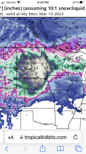
Long range, GFS is decent to let you know "something may be coming", but when it comes to snow amounts beyond 3 days out its a crap-shoot. Last Sunday was a great example of that. Still fun to watch the predictions on precipitation change twice per day.DO NOT look at the Tropical Tidbits 10:1 precipitation forecast between now and March 13th. Those of you in the Mobridge to Aberdeen areas might shit yourself. It currently is saying 54” of new snow.
Paddledogger
★★★★★ Legendary Member
Ya…I se that it has dramatically changed to half the amounts that it showed last night. I sure hope the mountains continue to get good spring snow storms. Need the Yellowstone to run hard for a while.
Sure looks like the Dakotas are likely to get dumped on over the next 8 days.
https://weatherstreet.com/models/gfs-slp-precip-forecast.php
https://weatherstreet.com/models/gfs-slp-precip-forecast.php
- Joined
- Jun 9, 2015
- Posts
- 4,839
- Likes
- 585
- Points
- 358
Agreed, starting tomorrow....Sure looks like the Dakotas are likely to get dumped on over the next 8 days.
https://weatherstreet.com/models/gfs-slp-precip-forecast.php
First wave comes through my area Monday night,second wave Thursday, let's always scary when they forecast "plow able " snow ,usually ends up a major dump.
Keep us updated on snow falls and storms that are likely to hit.
BBJ, I would just stay down there until mid-April at this point. Looks like day temperatures won't be consistently rising above freezing until after the 20th. We may have another several inches of snow by then too. There is a lot of snow to melt...going to take weeks to unthaw this State.Keep us updated on snow falls and storms that are likely to hit.
My wife gives me crap every time my pea brain says “unthaw”.BBJ, I would just stay down there until mid-April at this point. Looks like day temperatures won't be consistently rising above freezing until after the 20th. We may have another several inches of snow by then too. There is a lot of snow to melt...going to take weeks to unthaw this State.
I checked at noon and we're at 5.5inches in Dickinson with .41 inches of water.
Most of what one sees is the result of what's called the National Blend of Models (NBM for short), and it is literally as named.Hey @Allen, on the Bis NWS website, in the hourly forecast data area, where is that data pulled from? Computer models or do staff drop it in?
To freeze. To change from thawed to frozen.Ha ha. Keep frozen
Similar threads
- Replies
- 29
- Views
- 8K
Recent Posts
-
They Killed PEANUT!!!
- Latest: Obi-Wan
-
Property Tax Petition
- Latest: CatDaddy
-
Should ND legalize Marijuana
- Latest: CatDaddy
-
Migration 24
- Latest: 1lessdog
-
Elon Musk
- Latest: Obi-Wan
-
Walleyes eating frogs
- Latest: Ericb
-
John F. Kennedy
- Latest: NDbowman
-
Where are the youth deer pics?
- Latest: CatDaddy
-
Ice fishing Line
- Latest: Traxion
-
Paddle Fishing
- Latest: gunlover
-
Auto fetch and devices
- Latest: lunkerslayer
-
Dewalt 20 V or Milwaukee 18 V
- Latest: luvcatchingbass
-
What are you listening to these days?
- Latest: Zogman
-
Weighted comforter
- Latest: risingsun
-
Pedophiles in ND Legislature
- Latest: guywhofishes
-
Mille Lacs GIANT!
- Latest: svnmag
-
"Butt Out" Revisited
- Latest: Ruttin
-
NFL News (Vikings)
- Latest: CatDaddy
-
Rifle Deer Hunting Boredom
- Latest: 5575
-
Power tool charging station
- Latest: wslayer
Friends of NDA
Top Posters of the Month
-
This month: 46
-
- Posts
- 3,066
-
- Likes
- 1,255
-
-
This month: 19
-
- Posts
- 1,882
-
- Likes
- 3,176
-

