making your own lake maps with Lowrance

guywhofishes

Founding Member
Founding Member
Joined
Apr 21, 2015
Posts
28,715
Likes
4,108
Points
958
Location
Faaargo, ND
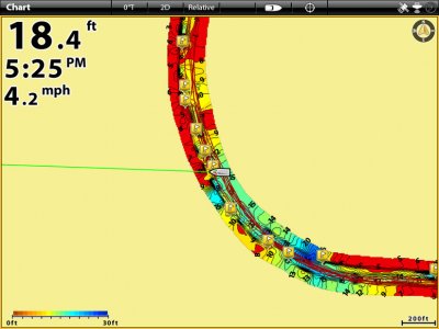
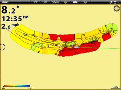
I have Lowrance HDS 8 gen2 and 9 Touch gen 2. I'd like to make my own contour maps of some lakes (areas of lakes more like it) that only have terrible maps (5 ft contours taken in 1953 type deal) on chips a person can buy.

My head spins when I try to figure out Navionics vs. Genesis vs. blah blah blah.

Anybody have good youtube videos, articles, or personal experience into the best way to go about it?

Thanks!


MuskyManiac

Founding Member
Founding Member
Joined
Apr 23, 2015
Posts
3,660
Likes
195
Points
313
Location
Grand Forks, ND
Record your sonar, upload to Insight Genesis, and wait for an e-mail telling you your map is done.

IMG_5752 (2).jpg

IMG_5753 (2).jpg

IMG_5754 (2).jpg
 

Captainbrad

Founding Member
Founding Member
Joined
Apr 20, 2015
Posts
683
Likes
142
Points
220
Location
Grand Forks
Just curious but how long that conversion take?

I use Autochart Live on Humminbird which is real time drawings.
 

MuskyManiac

Founding Member
Founding Member
Joined
Apr 23, 2015
Posts
3,660
Likes
195
Points
313
Location
Grand Forks, ND
Just curious but how long that conversion take?

I use Autochart Live on Humminbird which is real time drawings.

Depends on how many trips you're merging and if you are using offset data. Can takes minutes, hours, or the longest for me was about a day. Autochart Live would be awesome, but I'm a huge Lowrance fan.
 

guywhofishes

Founding Member
Founding Member
Thread starter
Joined
Apr 21, 2015
Posts
28,715
Likes
4,108
Points
958
Location
Faaargo, ND
Depends on how many trips you're merging and if you are using offset data. Can takes minutes, hours, or the longest for me was about a day. Autochart Live would be awesome, but I'm a huge Lowrance fan.

offset data?

I would also just want to log while fishing it. "Generate great map over a season without really trying" type thing.

- - - Updated - - -

Record your sonar, upload to Insight Genesis, and wait for an e-mail telling you your map is done.


what resolution? trail or full sonar log? what settings on LOwrance? Do I have to activate every time? Can I just put a monster chip in and record everything all the time?


powerman

Founding Member
Founding Member
Joined
Apr 24, 2015
Posts
544
Likes
18
Points
168
Location
ND
Your best bet is to record in the sl2 format rather than all channels. Sl2 will use your sonar data and how data. All channels will include sidescan which takes up a lot of room on a card. I have been looking for a good program as well,but don't think Genesis is the way for me. In the meantime I am just logging what I can.
 

Captainbrad

Founding Member
Founding Member
Joined
Apr 20, 2015
Posts
683
Likes
142
Points
220
Location
Grand Forks
Depends on how many trips you're merging and if you are using offset data. Can takes minutes, hours, or the longest for me was about a day. Autochart Live would be awesome, but I'm a huge Lowrance fan.

makes sense. Here are two screenshots of river maps I have done. The zoomed out one took about 15 minutes to make and the smaller about 5. For what I do this was a game changer.
 

Attachments

snp0921162533.jpg snp0825163531.jpg

guywhofishes

Founding Member
Founding Member
Thread starter
Joined
Apr 21, 2015
Posts
28,715
Likes
4,108
Points
958
Location
Faaargo, ND


dean nelson

Founding Member
Founding Member
Joined
Jul 17, 2015
Posts
8,270
Likes
66
Points
308
Location
Bismarck
One thing about map making is you need to hit it at two different directions 90° to each other to get the map hyper acurate especially if paralleling the shore. If you don't the maps are either a bit inaccurate all the way to totally jacked up. That's why river maps tend to not be very inaccurate as far as the whole river instead of what the rIver truly looks like bank to bank. The software is always trying to play contact the dots so if you only hit it one way it often extrapolates it incorrectly unless you go back and forth a ton like Musky obviously did on his spot. For instance this map I went back to the impotent spots near the points and it changed the map considerably compared to the stretches of shoreline where I just did a zig zag. It was pretty shocking to see it line the map up to what realy is down there compared to what was originally laid down on the first pass.

IMG_20160528_130028260.jpg

IMG_20160528_130620.jpg
 
Last edited:

powerman

Founding Member
Founding Member
Joined
Apr 24, 2015
Posts
544
Likes
18
Points
168
Location
ND
Looks good Dean. The reason I am looking for other software is I don't like the fact that I log for insight Genesis and they have access my info and everyone else's to make maps and I pay to give them my info.


How is the auto chart on memory cards? Do you use the zero lines card or some other cards?
 

walleyeman_1875

★★★ Legendary Member
Joined
Jan 3, 2016
Posts
413
Likes
32
Points
148
Location
Bismarck
Humminbird Onix is the only way to go if you want to make maps. AutoChart is easy to use and allows you to make maps on the water. You can also do water level offsets which allows you to dial in on the current elevation of the lake or river you are on.

The boat I have came with the Onix otherwise I'd never spend that kind of money....I'm sure glad I have one though. If you're looking for the best electronics, Humminbird is the only way to go. Also, the Onix can be update each time Humminbird has an upgrade.
 

Recent Posts

Friends of NDA

Top Posters of the Month

  • This month: 197
  • This month: 162
  • This month: 154
  • This month: 137
  • This month: 124
  • This month: 102
  • This month: 93
  • This month: 93
  • This month: 88
  • This month: 81
Top Bottom