Well first off more like 20 miles and you can bank on it having to do with it having some sort of funky setup because this is not remotely the norm for their forecast models. You can also bank on it changing massively before it gets here or Nebraska or Canada or wherever it hits.
You are using an out of date browser. It may not display this or other websites correctly.
You should upgrade or use an alternative browser.
You should upgrade or use an alternative browser.
March Blizzards
- Thread starter BrokenBackJack
- Start date
- Joined
- Nov 2, 2015
- Posts
- 777
- Likes
- 66
- Points
- 248
Paddledogger
★★★★★ Legendary Member
Forecast/ prediction maps like this make me shake my head. Sure is fun to worry about it for 7 days tho.
I would agree....I like looking at some of these sites to see just who the heck is a bit more accurate or who I can trust to make up a game plan for trips to the lake. I don't think you have to worry about the 7 days, as it seems the potential storm for next week seems to be a lot less probability for NoDak. But Friday, March 23rd could be something worth watching. So now we can watch how this changes for the next 11 days. Both of these sites indicates something is brewing for around the 23rd of March. Won't be bad if we can just get rid of what we have on the ground now before anymore snow storms. Otherwise....bring on the rain!!!
https://www.tropicaltidbits.com/analysis/models/
http://www.pivotalweather.com/model.php?m=gfs&p=sfcwind_mslp&rh=2018031206&fh=276&r=conus&dpdt=
I looked at this earlier. Very Interesting. A good rain would certainly be welcome.
I would agree....I like looking at some of these sites to see just who the heck is a bit more accurate or who I can trust to make up a game plan for trips to the lake. I don't think you have to worry about the 7 days, as it seems the potential storm for next week seems to be a lot less probability for NoDak. But Friday, March 23rd could be something worth watching. So now we can watch how this changes for the next 11 days. Both of these sites indicates something is brewing for around the 23rd of March. Won't be bad if we can just get rid of what we have on the ground now before anymore snow storms. Otherwise....bring on the rain!!!
https://www.tropicaltidbits.com/analysis/models/
http://www.pivotalweather.com/model.php?m=gfs&p=sfcwind_mslp&rh=2018031206&fh=276&r=conus&dpdt=
deleted___account
Founding Member
So what are you weather gurus seeing for predictions for this coming Sunday/Monday's precip event?
Global models continue to be consistent with bringing the main
western low/trough across the Rockies Saturday and into the western
plains on Sunday, developing southeast through the central Plains
through Monday. Even though this large system develops into the
central plains, its effects should be felt well to the north across
much of North Dakota. It appears that our area may see precipitation
as early as late Saturday night/Sunday morning, with better chances
Sunday afternoon through Monday. Temperature profiles suggest a
wintry mix of rain, freezing rain and snow for the southern half of
the state on Sunday, with enough dynamic cooling and the pulling of
cold air behind the system for all snow Sunday night through Monday
night. Precipitation amounts remain uncertain, but it appears a long
period of light snow Sunday night through Monday night.
It would certainly be nice to see a couple of inches of rain to melt this crappy snow and clean things up a bit.
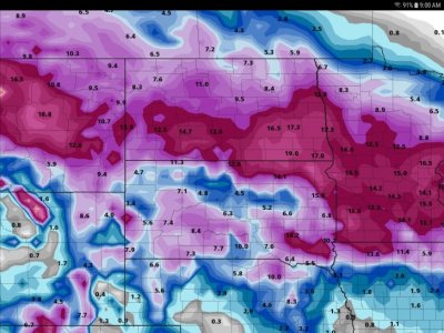
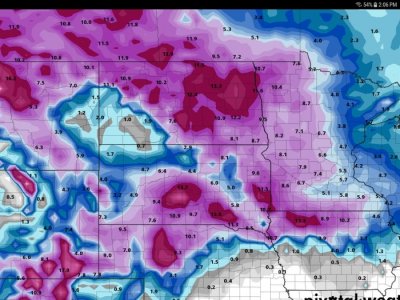
There are two storms coming and they don't seem to have a fucking clew on either! Every model run is bat shit crazy compared to the one before. Over all the brunt of the first wave is finally starting to get somewhat consistent with most being to our south and west. But hell here is the full 10 day total for both storms. These were I shit you not back to back model runs so needless to say consistency is not something they're consistent at!


My blower wouldn't handle the snow today (too wet). So I ran to Acme and rented a Toro Dingo (walk behind skid-steer). That thing moves snow! Problem is a track busted and now they want me to pay for it.
I rented a log splitter one weekend ACME in Bemidji..when it came time to use it..I discovered it had a cracked fuel line and was leaking the fuel I put in it. When I brought it back I told them that I fixed THIER SPLITTER FOR THEM and that I wanted my money back for the rental as I put on a new fuel line for them. They did refund my money so that made me less grouchy at the time.
There are two storms coming and they don't seem to have a fucking clew on either! Every model run is bat shit crazy compared to the one before. Over all the brunt of the first wave is finally starting to get somewhat consistent with most being to our south and west. But hell here is the full 10 day total for both storms. These were I shit you not back to back model runs so needless to say consistency is not something they're consistent at!
[/
On the last storm you put up this weather services model and my part of the state was in 14 inches, We never got a flake.
- Joined
- May 16, 2015
- Posts
- 4,699
- Likes
- 3,523
- Points
- 823
There are two storms coming and they don't seem to have a fucking clew on either! Every model run is bat shit crazy compared to the one before. Over all the brunt of the first wave is finally starting to get somewhat consistent with most being to our south and west. But hell here is the full 10 day total for both storms. These were I shit you not back to back model runs so needless to say consistency is not something they're consistent at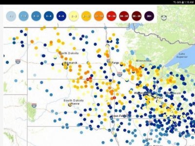
about half of forecast if going by recent years
With the way most of these predictions have been lately I am about ready to jab any meteorologists I see in the throat. Also mother nature needs to take a few extra Midol and knock this crap off
- Joined
- May 16, 2015
- Posts
- 4,699
- Likes
- 3,523
- Points
- 823
My wife sent me this the other day:
"Forecast: Snow possible anywhere from 0 to 145 inches. Maybe. Could start at 5, 6, 7, 8, 9 o'clock. Maybe today or maybe not. Possibly none."
Seems about right on.
"Forecast: Snow possible anywhere from 0 to 145 inches. Maybe. Could start at 5, 6, 7, 8, 9 o'clock. Maybe today or maybe not. Possibly none."
Seems about right on.
- Joined
- Oct 19, 2015
- Posts
- 2,564
- Likes
- 1,226
- Points
- 523
Yes that is so right. I think it is time to go back to the ol way of the" weather guess" as Mark Ess (RIP) used to say. Too much sophistication and technology these days that come up with a "MODEL" that tries to predict Ol Mother Nature. And we all know that is NEVER going to happen.
Snowing like a bitch here and the ten day now has 35 inches for north of Beulah. so that would obviously be interesting if it's actually really happened which I'm sure probably won't but with the way this spring is turning out who knows.
Similar threads
Recent Posts
-
Mozambique Rock/Surf
- Latest: MSA
-
Burleigh co. Ditches debate
- Latest: Rowdie
-
Walleye length limits on big 3
- Latest: walleyewanker
-
Spring has sprung-
- Latest: guywhofishes
-
ND Mushrooms
- Latest: SurvivalAmazon88
-
Ice angler cheats
- Latest: Auggie
-
Li time lithium batteries
- Latest: wslayer
-
Walkin and thinkin
- Latest: measure-it
-
Sled auger mount
- Latest: Travis wood outdoors
-
Spring snows 26
- Latest: Maddog
-
ND Otters?
- Latest: svnmag
-
CO2 Climate Scam
- Latest: Rowdie
-
Gilly YT
- Latest: svnmag
-
Predictions for deer season 26
- Latest: Rut2much
-
ND Senior Fishing lic Doubles
- Latest: Lycanthrope
-
Garden!!!!!!!!!!!!!
- Latest: Lycanthrope
-
Food porn
- Latest: SurvivalAmazon88
-
April Fool's day
- Latest: luvcatchingbass
-
What are you listening to these days?
- Latest: Davy Crockett
-
Butter Sauce Eggs YT
- Latest: svnmag
-
Some bad ice
- Latest: lunkerslayer
-
Jerimiah Johnson YT 26min
- Latest: lunkerslayer
-
Learning to weld..er trying to
- Latest: lunkerslayer
Friends of NDA
Top Posters of the Month
-
This month: 10
-
- Posts
- 3,677
-
- Likes
- 2,535
-
-
This month: 9
-
- Posts
- 1,603
-
- Likes
- 1,085
-


