Sorry, I am in advertising. You need to speak to production.Allen - please LRC us a Early Spring!!!
You are using an out of date browser. It may not display this or other websites correctly.
You should upgrade or use an alternative browser.
You should upgrade or use an alternative browser.
More Snow Next Week?
- Thread starter Slappy
- Start date
LBrandt
★★★★★ Legendary Member
Got some ice, just a fine coating, mostly snow now heavy at times with big flakes. LB


 LB
LB
Belongs to an ass-hole and not this ass-hole.I would absolutely get rid of that shelter belt.
Hourly forecast was spot on for the change-over this morning.I am pretty sure the forecast for last night included freezing rain until past midnight with a total snow accumulation of up to an inch, or so before 0700 today with snow accumulation really picking up as we go through Tuesday. Here by Bismarck it would seem they nailed it as I had less than an inch this morning at 0700 and as of now it's snowing pretty damn good.
So far we are getting the short end of the stick up north and that's just fine with me.
Speak for yourself. I bounce just fine. It just hurts for a whole lot longer than it used to. (Grin)KDM We don"t bounce like we used too. LB
We have about 5 inches here now
I'm up to something north of 6", but probably just shy of 7".
Enough to get the damn tractor stuck though when I dropped a wheel into the ditch. Grrr....
Enough to get the damn tractor stuck though when I dropped a wheel into the ditch. Grrr....
18-20” in W SD. Northern Black Hills has 36”. Sounds like prairie snow to th east is super wet. Going to be hard on the pheasants.
Probably 8+ inches of some of the wettest, heaviest snow I've ever seen in Fargo.
Next week's forecast is for below zero all week.
Whatever we don't get cleaned off the roads, sidewalks and driveways this week is gonna be around until March.
Whatever we don't get cleaned off the roads, sidewalks and driveways this week is gonna be around until March.
This is very bad for wildlife. 
- Joined
- May 16, 2015
- Posts
- 4,241
- Likes
- 2,644
- Points
- 698
Thanks Allen! Lots packed into that post and I appreciate the response. Did I interpret that right - you predict open water on Sak on March 1st?CatDaddy, first and foremost, I am not a meteorologist so I tread lightly on their turf for the most part. But I do dabble in climate stuff, and this subject would seem to lie somewhere between meteorology and climatology.
I never heard of this before now, but did read the links you provided. First off, it doesn't take a genius to predict that we will get a "storm" of some sorts on Feb 16th, plus or minus some number of days...and plus or minus a state away, or so. So, I would really want to hear from the people who specialize in this sort of mid-range forecasting. One thing I do know though is that it is not uncommon at all for the first half of winter to be very unlike the second half of winter. A few years ago we were in mid-late January and had very little to no snow across most of western ND and when the media called to ask what our spring flood season was going to look like, I would lead them through the numbers of snow-water equivalent on the countryside. I think we were generally less than an inch of SWE. At the end of the interview I just mentioned that while nothing is impossible, the remainder of winter would have to be pretty darn miserable to get us into the 4+ inches of SWE that puts us at risk of widespread flooding. Well, wouldn't you know it...come February it started snowing and was in general a pretty miserable second half of the winter and put us right around 4.5 inches of SWE across many of the small watersheds in western ND. We ended up with fairly minimal flooding, but it demonstrates how quickly things can change. The LRC would have to be considered a complete bust for that year.
That being said, there is a saying in the met world that the "trend is your friend". Basically that means if you don't have a good reason for forecasting a significant change in the pattern, you should probably hedge your bet with a continuation of the recent patterns. This LRC thing seems to fall under this category.
When I say I dabble in climate, it's because for years I had always told people that if I plotted long-term hydro data, if you squinted really hard you would see cycles in the raw data. So about 12 years ago, a couple mets and I tried to figure out how to get a grip on the cycles.
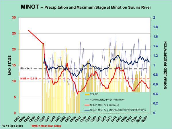
Here is a graph (busy I know), that shows the maximum stage for the Souris River at Minot and normalized precip. The raw data is in the blue and yellow, and that is what you need to squint at to see patterns. What one can also do though is put a 10-yr moving average on the data and that forms the black and red lines which clearly show a wet/dry pattern with a cycle of roughly 22-25 years from peak to peak. Interestingly, if one looks at the red line, you note that the last peak is substantially muted in comparison the previous peaks. What you are seeing there is the flood control storage bought by the U.S. in Rafferty and Grant Devine (formerly Alameda) dams up in Saskatchewan.

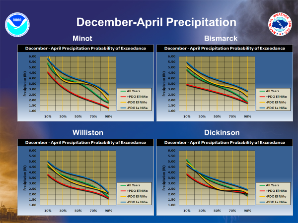
One of the fellows I was working with on this did his M.S. on climate, and he suggested we look at various El Nino Southern Oscillation (ENSO) patterns and combine them with the Pacific Decadal Oscillation (PDO). When you do this meteorologically, you get the following:

What one immediately gleans from the above is that a -PDO and a La Nina (blue lines) have a strong tendency to produce wetter than normal winters even though it isn't a slam dunk. There's definitely overlap with the other combinations.
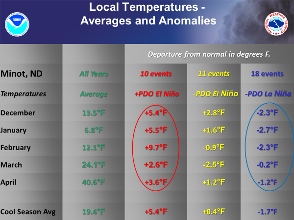
This is also found in the temperature data:

Note, as little as 0.5 degrees off of normal is noticeable by the layperson. I often ask people if they think the previous month was warmer, colder, or near normal. If the average for the month is off the historical average by as little as 0.5 degrees, about 90% of the people get it right.
Oh yeah, this winter is a -PDO with a La Nina combo. The past couple years were also La Nina, but we've now also been in a -PDO for a while, so take that for what you will.
OK, I think I've gone down the rabbit trail too far, so I'll just stop now.
7" of wet stuff here its 31 and wet out soon to be froze. Should be easy to stay on top shooting pheasants this weekend
wjschmaltz
★★★★★ Legendary Member
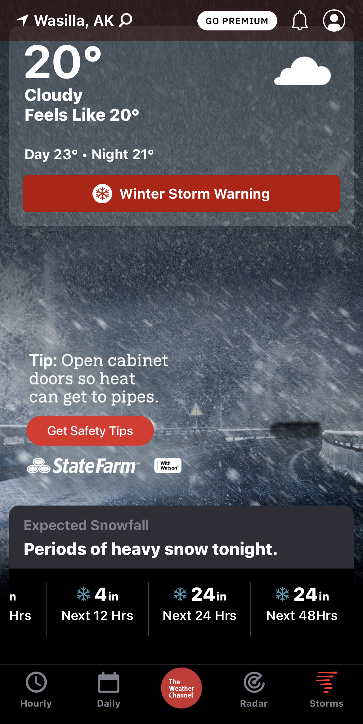
Up to 38 inches since last Wednesday at my place. Now they’re calling for up to 24 more by tomorrow. Sounds like we get a week or so of clear and cold starting Saturday. Wife shot a moose on Friday that is still hanging in the garage. My back is so damn smoked……

- Joined
- Apr 15, 2015
- Posts
- 14,421
- Likes
- 8,647
- Points
- 938
While I know this storm has a lot of snow in places, I wouldn't call it historic. We have maybe 5-8 inches. And our POST OFFICE is closed!! Old timers around here have never heard of the PO closing, and this is the 2nd time this year it's closed. The gas station across the street is open and our grocery store opened at 9. I made it to the oil which is 200 yds and the roads were plowed and easily drivable. Now I know it's started up again and we may get another 5 inches or so, but we do live in ND, is this that uncommon. Fk we're not Oklahoma, why is our PO closed and everyone freaking out?
Up to 38 inches since last Wednesday at my place. Now they’re calling for up to 24 more by tomorrow. Sounds like we get a week or so of clear and cold starting Saturday. Wife shot a moose on Friday that is still hanging in the garage. My back is so damn smoked...
Interesting that you don't get much wind up there. I saw some pics from AK that a friend posted yesterday and the snow was piled up at least 6'' on the top of a fence post.
Davey how much snow you get up in the turtle hills area
probably about 5 inches so far
Similar threads
- Replies
- 29
- Views
- 9K
Recent Posts
-
Stock market
- Latest: Fester
-
Open water?
- Latest: Wall-eyes
-
The Birds.........
- Latest: Retired Educator
-
Handgun Choices
- Latest: LBrandt
-
Memes
- Latest: Rowdie
-
You’re never a nobody.
- Latest: Ruttin
-
Oahe, Smelt, thoughts?
- Latest: 1850reata
-
Destination Fishing Trip??
- Latest: measure-it
-
Ready or not, here it comes.
- Latest: Lycanthrope
-
Jerkbaits In a Pool
- Latest: svnmag
-
NDSFC Annual Banquet April 26
- Latest: Honkerherms
-
March 29
- Latest: Kurtr
-
Garden!!!!!!!!!!!!!
- Latest: LBrandt
-
Possible ban ffs sota
- Latest: Captainbrad
-
Same Dean Nelson?
- Latest: Davey Crockett
-
Getting into Canada
- Latest: measure-it
-
What are you listening to these days?
- Latest: Jiffy
-
Real Estate Taxes
- Latest: wslayer
-
Pedophiles in ND Legislature
- Latest: NDSportsman
-
😁
- Latest: 5575
Friends of NDA
Top Posters of the Month
-
This month: 12
-
- Posts
- 2,075
-
- Likes
- 1,800
-
-
This month: 11
-
- Posts
- 3,521
-
- Likes
- 1,463
-
-
This month: 11
-
- Posts
- 2,145
-
- Likes
- 4,157
-
